Wangen geodata
Wangen (Zurich) is a populated place; located in Switzerland in Europe/Zurich (GMT+2) time zone. With population of 2,015 people, there are 827 cities with bigger population in this country. Compared to other cities in Switzerland, 76.2% of cities are located further ↓South; 69.9% of cities are located further ←West and 67.1% of cities have higher elevation than Wangen. Note1


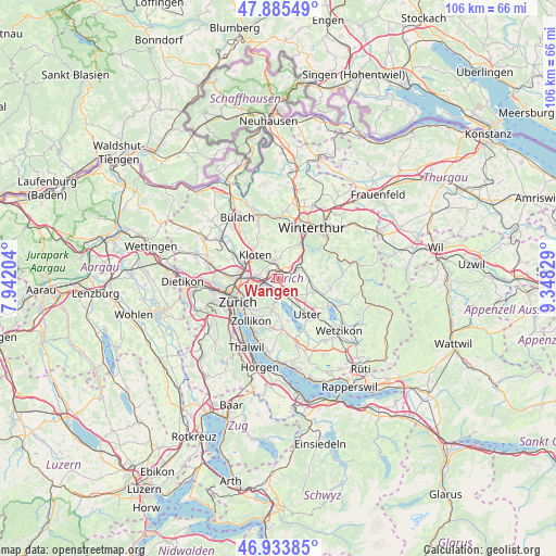
Wangen GPS coordinates[2]
47° 24' 42.552" North, 8° 38' 42.576" East
| Map corner | latitude | longitude |
|---|---|---|
| Upper-left | 47.88549°, | 7.94204° |
| Center: | 47.41182°, | 8.64516° |
| Lower-right: | 46.93385°, | 9.34829° |
| Map W x H: | 105.8×105.8 km | = 65.7×65.7mi |
| max Lat: | 47.76737° ⇑23.8% North |
| Wangen: | 47.41182° |
| min Lat: | ⇓76.2% South 45.83203° |
| min Long | Wangen | max Long |
| 5.97153° | 8.64516° | 10.44624° |
| W 69.9%⇐ | ⇒30.1% E |
Elevation
Elevation of Wangen is 442 m = 1450 ft, and this is 116.2 m = 381 ft below average elevation for this country.
| Max E: |
1845 m = 6053 ft | 67.1% |
| Avg. | 558.2 m = 1831 ft | |
| Wangen | 442 m = 1450 ft | |
Min E: |
197 m = 646 ft | 32.9% |
See also: Switzerland elevation on elevation.city.
Geographical zone
Wangen is located in North temperate zone (between Tropic of Cancer and the Arctic Circle). Distance of this North polar circle is 2129.5 km =1323.2 mi to North.| Distance of | km | miles | from Wangen |
|---|---|---|---|
| North Pole | 4735.4 | 2942.4 | to North |
| Arctic Circle | 2129.5 | 1323.2 | to North |
| Tropic Cancer | 2665.8 | 1656.5 | to South |
| Equator | 5271.7 | 3275.7 | to South |


Nearby cities:
15 places around Wangen: (largest is in red/bold)
• Brüttisellen
1.5 km =0.9 mi,  319°
319°
• Dietlikon / Dietlikon (Dorf)
2.1 km =1.3 mi,  289°
289°
• Dietlikon / Eichwiesen
2 km =1.2 mi, 293°
• Dübendorf
2.6 km =1.6 mi,  230°
230°
• Dübendorf / Aesch
2.4 km =1.5 mi,  217°
217°
• Dübendorf / Eglishölzli
1.4 km =0.9 mi,  245°
245°
• Dübendorf / Frickenbuck
2.5 km =1.6 mi,  203°
203°
• Dübendorf / Gfenn
2.1 km =1.3 mi,  177°
177°
• Dübendorf / Im Zwinggarten
2.3 km =1.4 mi, 250°
• Dübendorf / Kunklerstrasse
1.8 km =1.1 mi, 228°
• Dübendorf / Meiershofstrasse
2.8 km =1.7 mi,  236°
236°
• Dübendorf / Neuhausstrasse
2.6 km =1.6 mi, 225°
• Dübendorf / Sonnenberg
2.2 km =1.4 mi,  208°
208°
• Dübendorf / Stägenbuck
2 km =1.2 mi, 237°
• Kindhausen / Kindhausen (Dorf)
2.9 km =1.8 mi,  101°
101°
Sources, notices
• [Note1] Compared only with cities in Switzerland existing in our database
• [Src1] Map data: © OpenStreetMap contributors (CC-BY-SA)
• [Src2] Other city data from geonames.org with taken over terms of usage.
• [Src3] Geographical zone / Annual Mean Temperature by Robert A. Rohde @ Wikipedia
