Tägertschi geodata
Tägertschi (Bern) is a seat of a third-order administrative division; located in Switzerland in Europe/Zurich (GMT+2) time zone. In our database, there are 1823 cities with bigger population. Compared to other cities in Switzerland, 70.9% of cities are located further ↑North; 72.1% of cities are located further →East and 73.8% of cities have lower elevation than Tägertschi. Note1


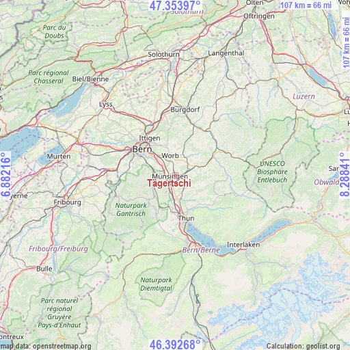
Tägertschi GPS coordinates[2]
46° 52' 31.728" North, 7° 35' 7.044" East
| Map corner | latitude | longitude |
|---|---|---|
| Upper-left | 47.35397°, | 6.88216° |
| Center: | 46.87548°, | 7.58529° |
| Lower-right: | 46.39268°, | 8.28841° |
| Map W x H: | 106.9×106.9 km | = 66.4×66.4mi |
| max Lat: | 47.76737° ⇑70.9% North |
| Tägertschi: | 46.87548° |
| min Lat: | ⇓29.1% South 45.83203° |
| min Long | Tägertschi | max Long |
| 5.97153° | 7.58529° | 10.44624° |
| W 27.9%⇐ | ⇒72.1% E |
Elevation
Elevation of Tägertschi is 605 m = 1985 ft, and this is 46.8 m = 154 ft above average elevation for this country.
| Max E: |
1845 m = 6053 ft | 26.2% |
| Tägertschi | 605 m 1985 ft | |
| Avg. | 558.2 m = 1831 ft | |
Min E: |
197 m = 646 ft | 73.8% |
See also: Switzerland elevation on elevation.city.
Geographical zone
Tägertschi is located in North temperate zone (between Tropic of Cancer and the Arctic Circle). Distance of this North polar circle is 2189.1 km =1360.2 mi to North.| Distance of | km | miles | from Tägertschi |
|---|---|---|---|
| North Pole | 4795 | 2979.5 | to North |
| Arctic Circle | 2189.1 | 1360.2 | to North |
| Tropic Cancer | 2606.1 | 1619.4 | to South |
| Equator | 5212.1 | 3238.6 | to South |


Nearby cities:
15 places around Tägertschi: (largest is in red/bold)
• Belp
6.8 km =4.2 mi,  284°
284°
• Biglen
6.4 km =4 mi,  28°
28°
• Gerzensee
5 km =3.1 mi,  217°
217°
• Kiesen
6.2 km =3.9 mi,  180°
180°
• Kirchdorf
6.7 km =4.2 mi,  204°
204°
• Konolfingen
2.7 km =1.7 mi,  81°
81°
• Linden
7.8 km =4.8 mi,  114°
114°
• Münsingen
1.9 km =1.2 mi,  261°
261°
• Oberdiessbach
4.5 km =2.8 mi,  147°
147°
• Oberhünigen
5.5 km =3.4 mi, 84°
• Rubigen
4 km =2.5 mi,  309°
309°
• Toffen
7.3 km =4.5 mi, 256°
• Wichtrach
2.9 km =1.8 mi,  191°
191°
• Worb
6.3 km =3.9 mi,  344°
344°
• Zäziwil
6.5 km =4 mi,  63°
63°
Sources, notices
• [Note1] Compared only with cities in Switzerland existing in our database
• [Src1] Map data: © OpenStreetMap contributors (CC-BY-SA)
• [Src2] Other city data from geonames.org with taken over terms of usage.
• [Src3] Geographical zone / Annual Mean Temperature by Robert A. Rohde @ Wikipedia
