Vuisternens-devant-Romont geodata
Vuisternens-devant-Romont (Fribourg) is a seat of a third-order administrative division; located in Switzerland in Europe/Zurich (GMT+2) time zone. In our database, there are 1823 cities with bigger population. Compared to other cities in Switzerland, 80.5% of cities are located further ↑North; 89% of cities are located further →East and 89% of cities have lower elevation than Vuisternens-devant-Romont. Note1
Administrative division(s):
- Level 1: Fribourg
- Level 2: Glâne District
- Level 3: Vuisternens-devant-Romont
Current local time in Vuisternens-devant-Romont:
07:39 AM, SaturdayDifference from your time zone: hours


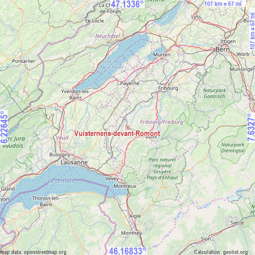
Vuisternens-devant-Romont GPS coordinates[2]
46° 39' 11.232" North, 6° 55' 46.488" East
| Map corner | latitude | longitude |
|---|---|---|
| Upper-left | 47.1336°, | 6.22645° |
| Center: | 46.65312°, | 6.92958° |
| Lower-right: | 46.16833°, | 7.6327° |
| Map W x H: | 107.3×107.3 km | = 66.7×66.7mi |
| max Lat: | 47.76737° ⇑80.5% North |
| Vuisternens-devant-Romont: | 46.65312° |
| min Lat: | ⇓19.5% South 45.83203° |
| min Long | Vuisternens-dev | max Long |
| 5.97153° | 6.92958° | 10.44624° |
| W 11%⇐ | ⇒89% E |
Elevation
Elevation of Vuisternens-devant-Romont is 801 m = 2628 ft, and this is 242.8 m = 797 ft above average elevation for this country.
| Max E: |
1845 m = 6053 ft | 11% |
| Vuisternens-devant-Romont | 801 m 2628 ft | |
| Avg. | 558.2 m = 1831 ft | |
Min E: |
197 m = 646 ft | 89% |
See also: Switzerland elevation on elevation.city.
Geographical zone
Vuisternens-devant-Romont is located in North temperate zone (between Tropic of Cancer and the Arctic Circle). Distance of this North polar circle is 2213.8 km =1375.6 mi to North.| Distance of | km | miles | from Vuisternens-devant-Romont |
|---|---|---|---|
| North Pole | 4819.7 | 2994.8 | to North |
| Arctic Circle | 2213.8 | 1375.6 | to North |
| Tropic Cancer | 2581.4 | 1604 | to South |
| Equator | 5187.3 | 3223.2 | to South |


Nearby cities:
15 places around Vuisternens-devant-Romont: (largest is in red/bold)
• Bulle
10.5 km =6.5 mi,  111°
111°
• Lucens
9.2 km =5.7 mi,  311°
311°
• Marsens
9.9 km =6.2 mi,  87°
87°
• Moudon
10.2 km =6.3 mi,  279°
279°
• Mézières
3 km =1.9 mi,  355°
355°
• Riaz
10.2 km =6.3 mi,  96°
96°
• Romont
4.9 km =3 mi,  350°
350°
• Rue
9 km =5.6 mi,  245°
245°
• Semsales
8.9 km =5.5 mi,  180°
180°
• Siviriez
4 km =2.5 mi, 278°
• Sorens
9.5 km =5.9 mi,  79°
79°
• Sâles
3.9 km =2.4 mi,  121°
121°
• Vaulruz
5.7 km =3.5 mi,  128°
128°
• Villaz-Saint-Pierre
7.8 km =4.8 mi,  15°
15°
• Vuadens
7.9 km =4.9 mi, 122°
Sources, notices
• [Note1] Compared only with cities in Switzerland existing in our database
• [Src1] Map data: © OpenStreetMap contributors (CC-BY-SA)
• [Src2] Other city data from geonames.org with taken over terms of usage.
• [Src3] Geographical zone / Annual Mean Temperature by Robert A. Rohde @ Wikipedia
