Villaz-Saint-Pierre geodata
Villaz-Saint-Pierre (Fribourg) is a populated place; located in Switzerland in Europe/Zurich (GMT+2) time zone. With population of 1,093 people, there are 1270 cities with bigger population in this country. Compared to other cities in Switzerland, 77.7% of cities are located further ↑North; 88.4% of cities are located further →East and 84.4% of cities have lower elevation than Villaz-Saint-Pierre. Note1


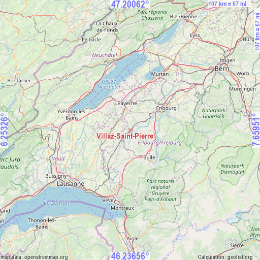
Villaz-Saint-Pierre GPS coordinates[2]
46° 43' 14.664" North, 6° 57' 22.968" East
| Map corner | latitude | longitude |
|---|---|---|
| Upper-left | 47.20062°, | 6.25326° |
| Center: | 46.72074°, | 6.95638° |
| Lower-right: | 46.23656°, | 7.65951° |
| Map W x H: | 107.2×107.2 km | = 66.6×66.6mi |
| max Lat: | 47.76737° ⇑77.7% North |
| Villaz-Saint-Pierre: | 46.72074° |
| min Lat: | ⇓22.3% South 45.83203° |
| min Long | Villaz-Saint-Pi | max Long |
| 5.97153° | 6.95638° | 10.44624° |
| W 11.6%⇐ | ⇒88.4% E |
Elevation
Elevation of Villaz-Saint-Pierre is 728 m = 2388 ft, and this is 169.8 m = 557 ft above average elevation for this country.
| Max E: |
1845 m = 6053 ft | 15.6% |
| Villaz-Saint-Pierre | 728 m 2388 ft | |
| Avg. | 558.2 m = 1831 ft | |
Min E: |
197 m = 646 ft | 84.4% |
See also: Switzerland elevation on elevation.city.
Geographical zone
Villaz-Saint-Pierre is located in North temperate zone (between Tropic of Cancer and the Arctic Circle). Distance of this North polar circle is 2206.3 km =1370.9 mi to North.| Distance of | km | miles | from Villaz-Saint-Pierre |
|---|---|---|---|
| North Pole | 4812.2 | 2990.2 | to North |
| Arctic Circle | 2206.3 | 1370.9 | to North |
| Tropic Cancer | 2588.9 | 1608.7 | to South |
| Equator | 5194.9 | 3228 | to South |


Nearby cities:
15 places around Villaz-Saint-Pierre: (largest is in red/bold)
• Autigny
5.2 km =3.2 mi,  69°
69°
• Avry-sur-Matran
11.3 km =7 mi,  48°
48°
• Ecuvillens
10.5 km =6.5 mi, 66°
• Granges
7 km =4.3 mi,  311°
311°
• Lucens
9 km =5.6 mi,  261°
261°
• Marsens
10.6 km =6.6 mi,  132°
132°
• Mézières
5.1 km =3.2 mi,  206°
206°
• Noréaz
10.5 km =6.5 mi,  31°
31°
• Romont
3.9 km =2.4 mi,  226°
226°
• Siviriez
9.2 km =5.7 mi,  220°
220°
• Sorens
9.3 km =5.8 mi, 128°
• Surpierre
7.9 km =4.9 mi,  290°
290°
• Sâles
9.7 km =6 mi,  172°
172°
• Vaulruz
11.3 km =7 mi, 167°
• Vuisternens-devant-Romont
7.8 km =4.8 mi,  195°
195°
Sources, notices
• [Note1] Compared only with cities in Switzerland existing in our database
• [Src1] Map data: © OpenStreetMap contributors (CC-BY-SA)
• [Src2] Other city data from geonames.org with taken over terms of usage.
• [Src3] Geographical zone / Annual Mean Temperature by Robert A. Rohde @ Wikipedia
