Sâles geodata
Sâles (Fribourg) is a populated place; located in Switzerland in Europe/Zurich (GMT+2) time zone. With population of 1,326 people, there are 1120 cities with bigger population in this country. Compared to other cities in Switzerland, 80.9% of cities are located further ↑North; 88.2% of cities are located further →East and 90.4% of cities have lower elevation than Sâles. Note1


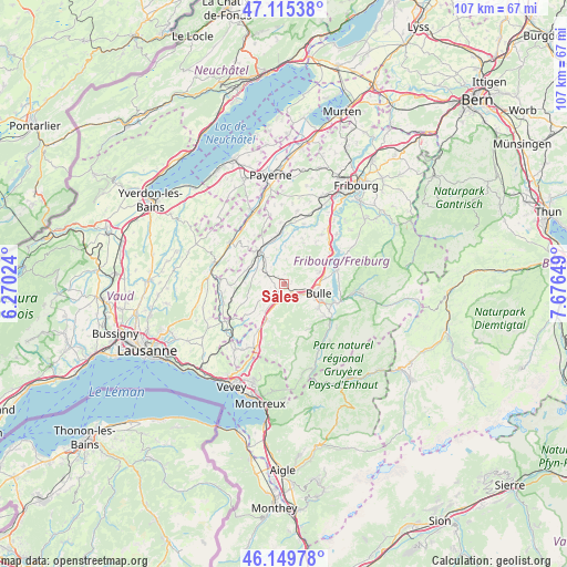
Sâles GPS coordinates[2]
46° 38' 5.028" North, 6° 58' 24.096" East
| Map corner | latitude | longitude |
|---|---|---|
| Upper-left | 47.11538°, | 6.27024° |
| Center: | 46.63473°, | 6.97336° |
| Lower-right: | 46.14978°, | 7.67649° |
| Map W x H: | 107.4×107.4 km | = 66.7×66.7mi |
| max Lat: | 47.76737° ⇑80.9% North |
| Sâles: | 46.63473° |
| min Lat: | ⇓19.1% South 45.83203° |
| min Long | Sâles | max Long |
| 5.97153° | 6.97336° | 10.44624° |
| W 11.8%⇐ | ⇒88.2% E |
Elevation
Elevation of Sâles is 826 m = 2710 ft, and this is 267.8 m = 879 ft above average elevation for this country.
| Max E: |
1845 m = 6053 ft | 9.6% |
| Sâles | 826 m 2710 ft | |
| Avg. | 558.2 m = 1831 ft | |
Min E: |
197 m = 646 ft | 90.4% |
See also: Switzerland elevation on elevation.city.
Geographical zone
Sâles is located in North temperate zone (between Tropic of Cancer and the Arctic Circle). Distance of this North polar circle is 2215.9 km =1376.9 mi to North.| Distance of | km | miles | from Sâles |
|---|---|---|---|
| North Pole | 4821.8 | 2996.1 | to North |
| Arctic Circle | 2215.9 | 1376.9 | to North |
| Tropic Cancer | 2579.4 | 1602.8 | to South |
| Equator | 5185.3 | 3222 | to South |


Nearby cities:
15 places around Sâles: (largest is in red/bold)
• Broc
10.1 km =6.3 mi,  108°
108°
• Bulle
6.6 km =4.1 mi, 106°
• Gruyères
10.1 km =6.3 mi,  124°
124°
• La Tour-de-Trême
7.5 km =4.7 mi, 110°
• Marsens
7 km =4.3 mi,  69°
69°
• Mézières
6.1 km =3.8 mi,  324°
324°
• Riaz
6.8 km =4.2 mi,  82°
82°
• Romont
8 km =5 mi,  328°
328°
• Semsales
7.6 km =4.7 mi,  206°
206°
• Siviriez
7.8 km =4.8 mi,  289°
289°
• Sorens
7.1 km =4.4 mi,  57°
57°
• Vaulruz
1.8 km =1.1 mi,  142°
142°
• Villaz-Saint-Pierre
9.7 km =6 mi,  352°
352°
• Vuadens
4 km =2.5 mi, 122°
• Vuisternens-devant-Romont
3.9 km =2.4 mi,  301°
301°
Sources, notices
• [Note1] Compared only with cities in Switzerland existing in our database
• [Src1] Map data: © OpenStreetMap contributors (CC-BY-SA)
• [Src2] Other city data from geonames.org with taken over terms of usage.
• [Src3] Geographical zone / Annual Mean Temperature by Robert A. Rohde @ Wikipedia
