Guotan geodata
Guotan (Shaanxi) is a seat of a fourth-order administrative division; located in China in Asia/Shanghai (GMT+8) time zone. In our database, there are 1268 cities with bigger population. Compared to other cities in China, 66.3% of cities are located further ↓South; 83.9% of cities are located further →East and 75% of cities have lower elevation than Guotan. Note1


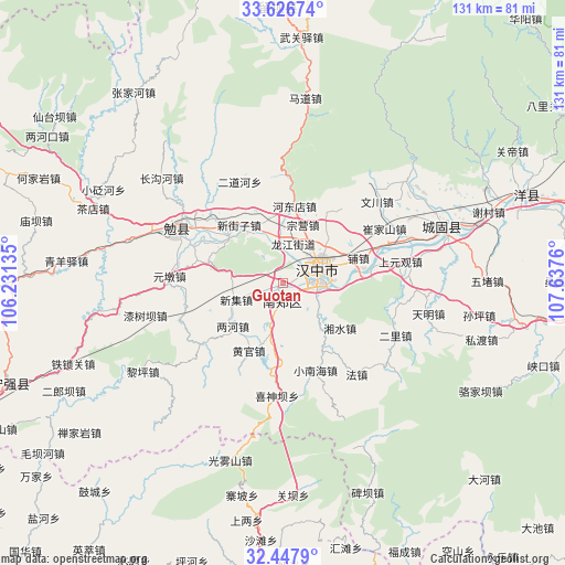
Guotan GPS coordinates[2]
33° 2' 21.444" North, 106° 56' 4.092" East
| Map corner | latitude | longitude |
|---|---|---|
| Upper-left | 33.62674°, | 106.23135° |
| Center: | 33.03929°, | 106.93447° |
| Lower-right: | 32.4479°, | 107.6376° |
| Map W x H: | 131.1×131.1 km | = 81.5×81.5mi |
| max Lat: | 53.31946° ⇑33.7% North |
| Guotan: | 33.03929° |
| min Lat: | ⇓66.3% South 18.22056° |
| min Long | Guotan | max Long |
| 75.07348° | 106.93447° | 134.28917° |
| W 16.1%⇐ | ⇒83.9% E |
Elevation
Elevation of Guotan is 521 m = 1709 ft, and this is 36.2 m = 119 ft above average elevation for this country.
| Max E: |
5622 m = 18445 ft | 25% |
| Guotan | 521 m 1709 ft | |
| Avg. | 484.8 m = 1591 ft | |
Min E: |
-3 m = -10 ft | 75% |
See also: China elevation on elevation.city.
Geographical zone
Guotan is located in North temperate zone (between Tropic of Cancer and the Arctic Circle). Distance of this Northern Tropic circle is 1067.7 km =663.4 mi to South.| Distance of | km | miles | from Guotan |
|---|---|---|---|
| North Pole | 6333.4 | 3935.4 | to North |
| Arctic Circle | 3727.5 | 2316.2 | to North |
| Tropic Cancer | 1067.7 | 663.4 | to South |
| Equator | 3673.6 | 2282.7 | to South |


Nearby cities:
15 places around Guotan: (largest is in red/bold)
• Changlin
11.9 km =7.4 mi,  346°
346°
• Dahekan
9.5 km =5.9 mi,  88°
88°
• Gaotai
7.8 km =4.8 mi,  253°
253°
• Hanzhong
9.1 km =5.7 mi,  64°
64°
• Hujiaying
8.5 km =5.3 mi,  101°
101°
• Liangshan
5.3 km =3.3 mi,  8°
8°
• Longjiang
9.6 km =6 mi, 13°
• Nanzheng Chengguanzhen
3.9 km =2.4 mi,  179°
179°
• Qili
12.2 km =7.6 mi,  68°
68°
• Qingshu
11.8 km =7.3 mi,  194°
194°
• Renshui
11.4 km =7.1 mi,  268°
268°
• Xieshui
4.5 km =2.8 mi,  211°
211°
• Xinji
11.1 km =6.9 mi, 251°
• Xinyuan
10.5 km =6.5 mi,  24°
24°
• Yangchun
3.1 km =1.9 mi,  257°
257°
Sources, notices
• [Note1] Compared only with cities in China existing in our database
• [Src1] Map data: © OpenStreetMap contributors (CC-BY-SA)
• [Src2] Other city data from geonames.org with taken over terms of usage.
• [Src3] Geographical zone / Annual Mean Temperature by Robert A. Rohde @ Wikipedia
