Zhuzhou geodata
Zhuzhou (Hunan) is a seat of a second-order administrative division; located in China in Asia/Shanghai (GMT+8) time zone. With population of 709,358 people, there are 87 cities with bigger population in this country. Compared to other cities in China, 75% of cities are located further ↑North; 56.6% of cities are located further →East and 69.5% of cities have higher elevation than Zhuzhou. Note1


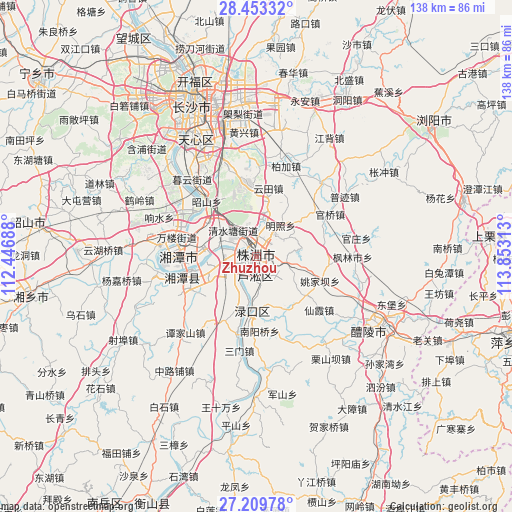
Zhuzhou GPS coordinates[2]
27° 49' 59.988" North, 113° 9' 0" East
| Map corner | latitude | longitude |
|---|---|---|
| Upper-left | 28.45332°, | 112.44688° |
| Center: | 27.83333°, | 113.15° |
| Lower-right: | 27.20978°, | 113.85313° |
| Map W x H: | 138.3×138.3 km | = 85.9×85.9mi |
| max Lat: | 53.31946° ⇑75% North |
| Zhuzhou: | 27.83333° |
| min Lat: | ⇓25% South 18.22056° |
| min Long | Zhuzhou | max Long |
| 75.07348° | 113.15° | 134.28917° |
| W 43.4%⇐ | ⇒56.6% E |
Elevation
Elevation of Zhuzhou is 54 m = 177 ft, and this is 430.8 m = 1413 ft below average elevation for this country.
| Max E: |
5622 m = 18445 ft | 69.5% |
| Avg. | 484.8 m = 1591 ft | |
| Zhuzhou | 54 m = 177 ft | |
Min E: |
-3 m = -10 ft | 30.5% |
See also: Zhuzhou elevation on elevation.city.
Geographical zone
Zhuzhou is located in North temperate zone (between Tropic of Cancer and the Arctic Circle). Distance of this Northern Tropic circle is 488.9 km =303.8 mi to South.| Distance of | km | miles | from Zhuzhou |
|---|---|---|---|
| North Pole | 6912.3 | 4295.1 | to North |
| Arctic Circle | 4306.4 | 2675.9 | to North |
| Tropic Cancer | 488.9 | 303.8 | to South |
| Equator | 3094.8 | 1923 | to South |


Nearby cities:
15 places around Zhuzhou: (largest is in red/bold)
• Changsha
44.3 km =27.5 mi,  336°
336°
• Datuo
32 km =19.9 mi,  321°
321°
• Dongjing
30.7 km =19.1 mi, 337°
• Dongtundu
40.6 km =25.2 mi, 343°
• Furong Beilu
47.9 km =29.8 mi, 339°
• Guitang
35.7 km =22.2 mi, 342°
• Lianhua
49.1 km =30.5 mi,  309°
309°
• Lukou
14.5 km =9 mi,  179°
179°
• Muyun
28 km =17.4 mi, 322°
• Pingtang
36.2 km =22.5 mi, 320°
• Qingyuan
34.9 km =21.7 mi,  334°
334°
• Xiangtan
24.6 km =15.3 mi,  274°
274°
• Xingsha
45.6 km =28.3 mi,  352°
352°
• Xishan
39.1 km =24.3 mi,  118°
118°
• Yisuhe
23.2 km =14.4 mi,  251°
251°
Sources, notices
• [Note1] Compared only with cities in China existing in our database
• [Src1] Map data: © OpenStreetMap contributors (CC-BY-SA)
• [Src2] Other city data from geonames.org with taken over terms of usage.
• [Src3] Geographical zone / Annual Mean Temperature by Robert A. Rohde @ Wikipedia
