Muyun geodata
Muyun (Hunan) is a seat of a fourth-order administrative division; located in China in Asia/Shanghai (GMT+8) time zone. In our database, there are 1268 cities with bigger population. Compared to other cities in China, 73.8% of cities are located further ↑North; 57.7% of cities are located further →East and 62.1% of cities have higher elevation than Muyun. Note1


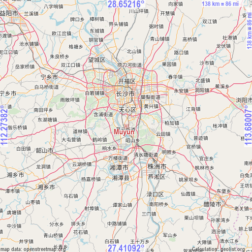
Muyun GPS coordinates[2]
28° 1' 59.988" North, 112° 58' 36.984" East
| Map corner | latitude | longitude |
|---|---|---|
| Upper-left | 28.65216°, | 112.27382° |
| Center: | 28.03333°, | 112.97694° |
| Lower-right: | 27.41092°, | 113.68007° |
| Map W x H: | 138×138 km | = 85.7×85.7mi |
| max Lat: | 53.31946° ⇑73.8% North |
| Muyun: | 28.03333° |
| min Lat: | ⇓26.2% South 18.22056° |
| min Long | Muyun | max Long |
| 75.07348° | 112.97694° | 134.28917° |
| W 42.3%⇐ | ⇒57.7% E |
Elevation
Elevation of Muyun is 87 m = 285 ft, and this is 397.8 m = 1305 ft below average elevation for this country.
| Max E: |
5622 m = 18445 ft | 62.1% |
| Avg. | 484.8 m = 1591 ft | |
| Muyun | 87 m = 285 ft | |
Min E: |
-3 m = -10 ft | 37.9% |
See also: China elevation on elevation.city.
Geographical zone
Muyun is located in North temperate zone (between Tropic of Cancer and the Arctic Circle). Distance of this Northern Tropic circle is 511.1 km =317.6 mi to South.| Distance of | km | miles | from Muyun |
|---|---|---|---|
| North Pole | 6890 | 4281.2 | to North |
| Arctic Circle | 4284.2 | 2662.1 | to North |
| Tropic Cancer | 511.1 | 317.6 | to South |
| Equator | 3117 | 1936.8 | to South |


Nearby cities:
15 places around Muyun: (largest is in red/bold)
• Bairuopu
25.4 km =15.8 mi,  316°
316°
• Changsha
18.4 km =11.4 mi,  358°
358°
• Datuo
4 km =2.5 mi, 316°
• Dongjing
7.9 km =4.9 mi,  40°
40°
• Dongtundu
17.6 km =10.9 mi,  17°
17°
• Furong Beilu
22.7 km =14.1 mi,  0°
0°
• Guitang
13.5 km =8.4 mi,  28°
28°
• Lianhua
22.7 km =14.1 mi,  294°
294°
• Pingtang
8.3 km =5.2 mi,  313°
313°
• Qingyuan
9.6 km =6 mi,  12°
12°
• Wangyue
23.3 km =14.5 mi,  345°
345°
• Xiangtan
21.7 km =13.5 mi,  200°
200°
• Xingsha
25.4 km =15.8 mi, 25°
• Yisuhe
30.2 km =18.8 mi,  189°
189°
• Zhuzhou
28 km =17.4 mi,  142°
142°
Sources, notices
• [Note1] Compared only with cities in China existing in our database
• [Src1] Map data: © OpenStreetMap contributors (CC-BY-SA)
• [Src2] Other city data from geonames.org with taken over terms of usage.
• [Src3] Geographical zone / Annual Mean Temperature by Robert A. Rohde @ Wikipedia
