Zhenzhushan geodata
Zhenzhushan (Jiangxi) is a seat of a fourth-order administrative division; located in China in Asia/Shanghai (GMT+8) time zone. In our database, there are 1268 cities with bigger population. Compared to other cities in China, 63.3% of cities are located further ↑North; 68.6% of cities are located further ←West and 55.6% of cities have lower elevation than Zhenzhushan. Note1


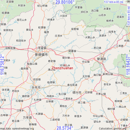
Zhenzhushan GPS coordinates[2]
29° 11' 20.652" North, 117° 27' 40.464" East
| Map corner | latitude | longitude |
|---|---|---|
| Upper-left | 29.80106°, | 116.75812° |
| Center: | 29.18907°, | 117.46124° |
| Lower-right: | 28.5734°, | 118.16437° |
| Map W x H: | 136.5×136.5 km | = 84.8×84.8mi |
| max Lat: | 53.31946° ⇑63.3% North |
| Zhenzhushan: | 29.18907° |
| min Lat: | ⇓36.7% South 18.22056° |
| min Long | Zhenzhushan | max Long |
| 75.07348° | 117.46124° | 134.28917° |
| W 68.6%⇐ | ⇒31.4% E |
Elevation
Elevation of Zhenzhushan is 212 m = 696 ft, and this is 272.8 m = 895 ft below average elevation for this country.
| Max E: |
5622 m = 18445 ft | 44.4% |
| Avg. | 484.8 m = 1591 ft | |
| Zhenzhushan | 212 m = 696 ft | |
Min E: |
-3 m = -10 ft | 55.6% |
See also: China elevation on elevation.city.
Geographical zone
Zhenzhushan is located in North temperate zone (between Tropic of Cancer and the Arctic Circle). Distance of this Northern Tropic circle is 639.6 km =397.4 mi to South.| Distance of | km | miles | from Zhenzhushan |
|---|---|---|---|
| North Pole | 6761.5 | 4201.4 | to North |
| Arctic Circle | 4155.7 | 2582.2 | to North |
| Tropic Cancer | 639.6 | 397.4 | to South |
| Equator | 3245.5 | 2016.7 | to South |


Nearby cities:
15 places around Zhenzhushan: (largest is in red/bold)
• Fengzhou
15.5 km =9.6 mi,  144°
144°
• Fuchun
17 km =10.6 mi,  27°
27°
• Gaojia
22.3 km =13.9 mi,  200°
200°
• Hongyan
16.6 km =10.3 mi,  179°
179°
• Jialu
23.9 km =14.9 mi,  40°
40°
• Jingcheng
25.9 km =16.1 mi,  294°
294°
• Lingang
23.2 km =14.4 mi,  219°
219°
• Longshan
23.5 km =14.6 mi,  67°
67°
• Taibai
24.9 km =15.5 mi,  117°
117°
• Xianghu
20.7 km =12.9 mi,  317°
317°
• Xiangtun
21.5 km =13.4 mi,  159°
159°
• Xucun
9.1 km =5.7 mi,  93°
93°
• Yongshan
14.9 km =9.3 mi,  252°
252°
• Zhentou
8.7 km =5.4 mi,  4°
4°
• Zhongyun
22.1 km =13.7 mi,  80°
80°
Sources, notices
• [Note1] Compared only with cities in China existing in our database
• [Src1] Map data: © OpenStreetMap contributors (CC-BY-SA)
• [Src2] Other city data from geonames.org with taken over terms of usage.
• [Src3] Geographical zone / Annual Mean Temperature by Robert A. Rohde @ Wikipedia
