Gaojia geodata
Gaojia (Jiangxi) is a seat of a fourth-order administrative division; located in China in Asia/Shanghai (GMT+8) time zone. In our database, there are 1268 cities with bigger population. Compared to other cities in China, 65.5% of cities are located further ↑North; 68.2% of cities are located further ←West and 66.8% of cities have higher elevation than Gaojia. Note1


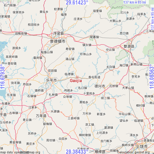
Gaojia GPS coordinates[2]
29° 0' 3.996" North, 117° 22' 57" East
| Map corner | latitude | longitude |
|---|---|---|
| Upper-left | 29.61423°, | 116.67938° |
| Center: | 29.00111°, | 117.3825° |
| Lower-right: | 28.38433°, | 118.08563° |
| Map W x H: | 136.8×136.8 km | = 85×85mi |
| max Lat: | 53.31946° ⇑65.5% North |
| Gaojia: | 29.00111° |
| min Lat: | ⇓34.5% South 18.22056° |
| min Long | Gaojia | max Long |
| 75.07348° | 117.3825° | 134.28917° |
| W 68.2%⇐ | ⇒31.8% E |
Elevation
Elevation of Gaojia is 65 m = 213 ft, and this is 419.8 m = 1377 ft below average elevation for this country.
| Max E: |
5622 m = 18445 ft | 66.8% |
| Avg. | 484.8 m = 1591 ft | |
| Gaojia | 65 m = 213 ft | |
Min E: |
-3 m = -10 ft | 33.2% |
See also: China elevation on elevation.city.
Geographical zone
Gaojia is located in North temperate zone (between Tropic of Cancer and the Arctic Circle). Distance of this Northern Tropic circle is 618.7 km =384.4 mi to South.| Distance of | km | miles | from Gaojia |
|---|---|---|---|
| North Pole | 6782.4 | 4214.4 | to North |
| Arctic Circle | 4176.6 | 2595.2 | to North |
| Tropic Cancer | 618.7 | 384.4 | to South |
| Equator | 3224.6 | 2003.7 | to South |


Nearby cities:
15 places around Gaojia: (largest is in red/bold)
• Fengzhou
18.7 km =11.6 mi,  63°
63°
• Hongyan
8.9 km =5.5 mi, 61°
• Jiedu
21.7 km =13.5 mi,  254°
254°
• Lilin
26.1 km =16.2 mi,  234°
234°
• Lingang
7.8 km =4.8 mi,  293°
293°
• Lusi
13.7 km =8.5 mi,  214°
214°
• Mingkou
10.3 km =6.4 mi,  153°
153°
• Shiligang
18 km =11.2 mi,  143°
143°
• Shuangtian
22.9 km =14.2 mi, 285°
• Tanbuqiao
24 km =14.9 mi,  88°
88°
• Wukou
14.1 km =8.8 mi,  260°
260°
• Xiangtun
15.4 km =9.6 mi, 87°
• Yongshan
17.8 km =11.1 mi,  338°
338°
• Zhenzhushan
22.3 km =13.9 mi,  20°
20°
• Zhongbu
19.2 km =11.9 mi, 205°
Sources, notices
• [Note1] Compared only with cities in China existing in our database
• [Src1] Map data: © OpenStreetMap contributors (CC-BY-SA)
• [Src2] Other city data from geonames.org with taken over terms of usage.
• [Src3] Geographical zone / Annual Mean Temperature by Robert A. Rohde @ Wikipedia
