Hongyan geodata
Hongyan (Jiangxi) is a seat of a fourth-order administrative division; located in China in Asia/Shanghai (GMT+8) time zone. In our database, there are 1268 cities with bigger population. Compared to other cities in China, 65% of cities are located further ↑North; 68.6% of cities are located further ←West and 68.2% of cities have higher elevation than Hongyan. Note1


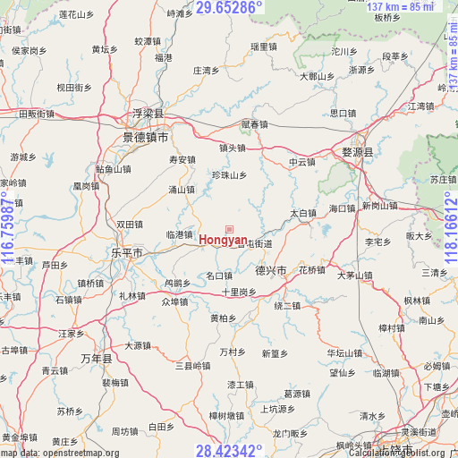
Hongyan GPS coordinates[2]
29° 2' 23.892" North, 117° 27' 46.764" East
| Map corner | latitude | longitude |
|---|---|---|
| Upper-left | 29.65286°, | 116.75987° |
| Center: | 29.03997°, | 117.46299° |
| Lower-right: | 28.42342°, | 118.16612° |
| Map W x H: | 136.7×136.7 km | = 84.9×84.9mi |
| max Lat: | 53.31946° ⇑65% North |
| Hongyan: | 29.03997° |
| min Lat: | ⇓35% South 18.22056° |
| min Long | Hongyan | max Long |
| 75.07348° | 117.46299° | 134.28917° |
| W 68.6%⇐ | ⇒31.4% E |
Elevation
Elevation of Hongyan is 59 m = 194 ft, and this is 425.8 m = 1397 ft below average elevation for this country.
| Max E: |
5622 m = 18445 ft | 68.2% |
| Avg. | 484.8 m = 1591 ft | |
| Hongyan | 59 m = 194 ft | |
Min E: |
-3 m = -10 ft | 31.8% |
See also: China elevation on elevation.city.
Geographical zone
Hongyan is located in North temperate zone (between Tropic of Cancer and the Arctic Circle). Distance of this Northern Tropic circle is 623 km =387.1 mi to South.| Distance of | km | miles | from Hongyan |
|---|---|---|---|
| North Pole | 6778.1 | 4211.7 | to North |
| Arctic Circle | 4172.2 | 2592.5 | to North |
| Tropic Cancer | 623 | 387.1 | to South |
| Equator | 3228.9 | 2006.3 | to South |


Nearby cities:
15 places around Hongyan: (largest is in red/bold)
• Fengzhou
9.8 km =6.1 mi,  65°
65°
• Gaojia
8.9 km =5.5 mi,  241°
241°
• Lingang
15.1 km =9.4 mi,  265°
265°
• Lusi
22.1 km =13.7 mi,  224°
224°
• Mingkou
13.9 km =8.6 mi,  193°
193°
• Shiligang
18.9 km =11.7 mi,  170°
170°
• Sizhou
24 km =14.9 mi,  88°
88°
• Taibai
22.6 km =14 mi,  76°
76°
• Tanbuqiao
16.6 km =10.3 mi,  102°
102°
• Wukou
22.7 km =14.1 mi,  253°
253°
• Xiangtun
8.3 km =5.2 mi,  115°
115°
• Xucun
18.3 km =11.4 mi,  29°
29°
• Yongshan
18.9 km =11.7 mi,  310°
310°
• Zhentou
25.2 km =15.7 mi,  1°
1°
• Zhenzhushan
16.6 km =10.3 mi,  359°
359°
Sources, notices
• [Note1] Compared only with cities in China existing in our database
• [Src1] Map data: © OpenStreetMap contributors (CC-BY-SA)
• [Src2] Other city data from geonames.org with taken over terms of usage.
• [Src3] Geographical zone / Annual Mean Temperature by Robert A. Rohde @ Wikipedia
