Zhaoxiang geodata
Zhaoxiang (Shanghai) is a seat of a fourth-order administrative division; located in China in Asia/Shanghai (GMT+8) time zone. In our database, there are 1268 cities with bigger population. Compared to other cities in China, 55.9% of cities are located further ↓South; 88.6% of cities are located further ←West and 95.9% of cities have higher elevation than Zhaoxiang. Note1


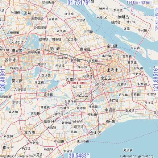
Zhaoxiang GPS coordinates[2]
31° 9' 6.984" North, 121° 11' 31.308" East
| Map corner | latitude | longitude |
|---|---|---|
| Upper-left | 31.75176°, | 120.48891° |
| Center: | 31.15194°, | 121.19203° |
| Lower-right: | 30.5483°, | 121.89516° |
| Map W x H: | 133.8×133.8 km | = 83.1×83.1mi |
| max Lat: | 53.31946° ⇑44.1% North |
| Zhaoxiang: | 31.15194° |
| min Lat: | ⇓55.9% South 18.22056° |
| min Long | Zhaoxiang | max Long |
| 75.07348° | 121.19203° | 134.28917° |
| W 88.6%⇐ | ⇒11.4% E |
Elevation
Elevation of Zhaoxiang is 6 m = 20 ft, and this is 478.8 m = 1571 ft below average elevation for this country.
| Max E: |
5622 m = 18445 ft | 95.9% |
| Avg. | 484.8 m = 1591 ft | |
| Zhaoxiang | 6 m = 20 ft | |
Min E: |
-3 m = -10 ft | 4.1% |
See also: China elevation on elevation.city.
Geographical zone
Zhaoxiang is located in North temperate zone (between Tropic of Cancer and the Arctic Circle). Distance of this Northern Tropic circle is 857.9 km =533.1 mi to South.| Distance of | km | miles | from Zhaoxiang |
|---|---|---|---|
| North Pole | 6543.3 | 4065.8 | to North |
| Arctic Circle | 3937.4 | 2446.6 | to North |
| Tropic Cancer | 857.9 | 533.1 | to South |
| Equator | 3463.8 | 2152.3 | to South |


Nearby cities:
15 places around Zhaoxiang: (largest is in red/bold)
• Baihe
12.7 km =7.9 mi,  335°
335°
• Chonggu
6.1 km =3.8 mi, 340°
• Dongjing
9.9 km =6.2 mi,  137°
137°
• Fangsong
13.2 km =8.2 mi,  181°
181°
• Huacao
10.9 km =6.8 mi,  55°
55°
• Huaxin
10.9 km =6.8 mi,  13°
13°
• Jiuting
12.1 km =7.5 mi,  101°
101°
• Sheshan
5.8 km =3.6 mi,  192°
192°
• Sijing
8.4 km =5.2 mi,  119°
119°
• Songjiang
13.1 km =8.1 mi,  170°
170°
• Xianghuaqiao
7.6 km =4.7 mi,  289°
289°
• Xiayang
7.3 km =4.5 mi,  268°
268°
• Xujing
8 km =5 mi,  70°
70°
• Yingpu
8.2 km =5.1 mi, 272°
• Zhongshan
13.8 km =8.6 mi,  158°
158°
Sources, notices
• [Note1] Compared only with cities in China existing in our database
• [Src1] Map data: © OpenStreetMap contributors (CC-BY-SA)
• [Src2] Other city data from geonames.org with taken over terms of usage.
• [Src3] Geographical zone / Annual Mean Temperature by Robert A. Rohde @ Wikipedia
