Chonggu geodata
Chonggu (Shanghai) is a seat of a fourth-order administrative division; located in China in Asia/Shanghai (GMT+8) time zone. In our database, there are 1268 cities with bigger population. Compared to other cities in China, 56.3% of cities are located further ↓South; 88.5% of cities are located further ←West and 98.9% of cities have higher elevation than Chonggu. Note1


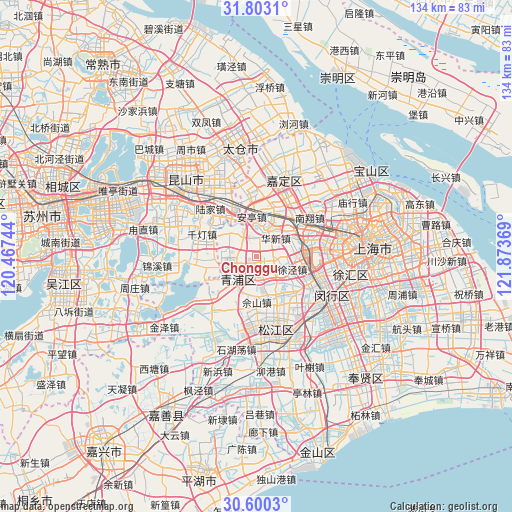
Chonggu GPS coordinates[2]
31° 12' 12.996" North, 121° 10' 14.016" East
| Map corner | latitude | longitude |
|---|---|---|
| Upper-left | 31.8031°, | 120.46744° |
| Center: | 31.20361°, | 121.17056° |
| Lower-right: | 30.6003°, | 121.87369° |
| Map W x H: | 133.7×133.7 km | = 83.1×83.1mi |
| max Lat: | 53.31946° ⇑43.7% North |
| Chonggu: | 31.20361° |
| min Lat: | ⇓56.3% South 18.22056° |
| min Long | Chonggu | max Long |
| 75.07348° | 121.17056° | 134.28917° |
| W 88.5%⇐ | ⇒11.5% E |
Elevation
Elevation of Chonggu is 3 m = 10 ft, and this is 481.8 m = 1581 ft below average elevation for this country.
| Max E: |
5622 m = 18445 ft | 98.9% |
| Avg. | 484.8 m = 1591 ft | |
| Chonggu | 3 m = 10 ft | |
Min E: |
-3 m = -10 ft | 1.1% |
See also: China elevation on elevation.city.
Geographical zone
Chonggu is located in North temperate zone (between Tropic of Cancer and the Arctic Circle). Distance of this Northern Tropic circle is 863.6 km =536.6 mi to South.| Distance of | km | miles | from Chonggu |
|---|---|---|---|
| North Pole | 6537.5 | 4062.2 | to North |
| Arctic Circle | 3931.7 | 2443 | to North |
| Tropic Cancer | 863.6 | 536.6 | to South |
| Equator | 3469.5 | 2155.8 | to South |


Nearby cities:
15 places around Chonggu: (largest is in red/bold)
• Anting
10.7 km =6.6 mi,  353°
353°
• Baihe
6.7 km =4.2 mi,  331°
331°
• Dianshanhu
14 km =8.7 mi,  261°
261°
• Huacao
11.1 km =6.9 mi,  88°
88°
• Huangdu
8.9 km =5.5 mi,  23°
23°
• Huaqiao
13.6 km =8.5 mi,  323°
323°
• Huaxin
6.6 km =4.1 mi,  43°
43°
• Jiangqiao
15.2 km =9.4 mi,  75°
75°
• Sheshan
11.4 km =7.1 mi,  175°
175°
• Sijing
13.6 km =8.5 mi,  136°
136°
• Xianghuaqiao
6 km =3.7 mi,  237°
237°
• Xiayang
7.9 km =4.9 mi,  220°
220°
• Xujing
10.1 km =6.3 mi,  107°
107°
• Yingpu
8.2 km =5.1 mi,  228°
228°
• Zhaoxiang
6.1 km =3.8 mi,  160°
160°
Sources, notices
• [Note1] Compared only with cities in China existing in our database
• [Src1] Map data: © OpenStreetMap contributors (CC-BY-SA)
• [Src2] Other city data from geonames.org with taken over terms of usage.
• [Src3] Geographical zone / Annual Mean Temperature by Robert A. Rohde @ Wikipedia
