Zhaoshi geodata
Zhaoshi (Hunan) is a seat of a fourth-order administrative division; located in China in Asia/Shanghai (GMT+8) time zone. In our database, there are 1268 cities with bigger population. Compared to other cities in China, 62.9% of cities are located further ↑North; 74.3% of cities are located further →East and 78.8% of cities have lower elevation than Zhaoshi. Note1


Zhaoshi GPS coordinates[2]
29° 14' 8.664" North, 109° 25' 31.872" East
| Map corner | latitude | longitude |
|---|---|---|
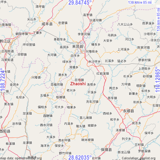
| Upper-left | 29.84745°, | 108.7224° |
| Center: | 29.23574°, | 109.42552° |
| Lower-right: | 28.62035°, | 110.12865° |
| Map W x H: | 136.4×136.4 km | = 84.8×84.8mi |
| max Lat: | 53.31946° ⇑62.9% North |
| Zhaoshi: | 29.23574° |
| min Lat: | ⇓37.1% South 18.22056° |
| min Long | Zhaoshi | max Long |
| 75.07348° | 109.42552° | 134.28917° |
| W 25.7%⇐ | ⇒74.3% E |
Elevation
Elevation of Zhaoshi is 645 m = 2116 ft, and this is 160.2 m = 526 ft above average elevation for this country.
| Max E: |
5622 m = 18445 ft | 21.2% |
| Zhaoshi | 645 m 2116 ft | |
| Avg. | 484.8 m = 1591 ft | |
Min E: |
-3 m = -10 ft | 78.8% |
See also: China elevation on elevation.city.
Geographical zone
Zhaoshi is located in North temperate zone (between Tropic of Cancer and the Arctic Circle). Distance of this Northern Tropic circle is 644.8 km =400.7 mi to South.| Distance of | km | miles | from Zhaoshi |
|---|---|---|---|
| North Pole | 6756.4 | 4198.2 | to North |
| Arctic Circle | 4150.5 | 2579 | to North |
| Tropic Cancer | 644.8 | 400.7 | to South |
| Equator | 3250.7 | 2019.9 | to South |


Nearby cities:
15 places around Zhaoshi: (largest is in red/bold)
• Bishagou
20 km =12.4 mi,  53°
53°
• Chenzhouzhai
5.6 km =3.5 mi,  41°
41°
• Jiajiaba
10.9 km =6.8 mi,  201°
201°
• Laoxingchang
12 km =7.5 mi,  221°
221°
• Liangshuijing
15.6 km =9.7 mi,  292°
292°
• Longzui
12.3 km =7.6 mi,  332°
332°
• Luotache
9.9 km =6.2 mi,  107°
107°
• Maoping
13.4 km =8.3 mi,  27°
27°
• Mengxihu
13.6 km =8.5 mi,  158°
158°
• Piduhe
10.6 km =6.6 mi,  270°
270°
• Shangzhai
20.1 km =12.5 mi,  322°
322°
• Shuishaping
20.2 km =12.6 mi, 38°
• Xiluo
19.6 km =12.2 mi,  11°
11°
• Xinzhaipo
5.5 km =3.4 mi,  356°
356°
• Xishaping
14.4 km =8.9 mi,  136°
136°
Sources, notices
• [Note1] Compared only with cities in China existing in our database
• [Src1] Map data: © OpenStreetMap contributors (CC-BY-SA)
• [Src2] Other city data from geonames.org with taken over terms of usage.
• [Src3] Geographical zone / Annual Mean Temperature by Robert A. Rohde @ Wikipedia
