Zhaoqing geodata
Zhaoqing (Guangdong) is a seat of a second-order administrative division; located in China in Asia/Shanghai (GMT+8) time zone. With population of 361,969 people, there are 161 cities with bigger population in this country. Compared to other cities in China, 94.2% of cities are located further ↑North; 60.2% of cities are located further →East and 92.7% of cities have higher elevation than Zhaoqing. Note1


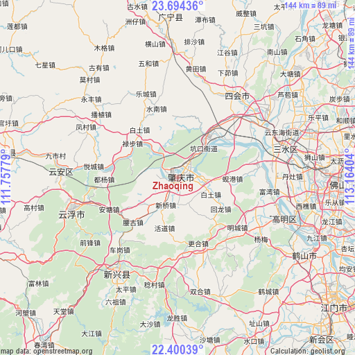
Zhaoqing GPS coordinates[2]
23° 2' 56.148" North, 112° 27' 39.276" East
| Map corner | latitude | longitude |
|---|---|---|
| Upper-left | 23.69436°, | 111.75779° |
| Center: | 23.04893°, | 112.46091° |
| Lower-right: | 22.40039°, | 113.16404° |
| Map W x H: | 143.9×143.9 km | = 89.4×89.4mi |
| max Lat: | 53.31946° ⇑94.2% North |
| Zhaoqing: | 23.04893° |
| min Lat: | ⇓5.8% South 18.22056° |
| min Long | Zhaoqing | max Long |
| 75.07348° | 112.46091° | 134.28917° |
| W 39.8%⇐ | ⇒60.2% E |
Elevation
Elevation of Zhaoqing is 8 m = 26 ft, and this is 476.8 m = 1564 ft below average elevation for this country.
| Max E: |
5622 m = 18445 ft | 92.7% |
| Avg. | 484.8 m = 1591 ft | |
| Zhaoqing | 8 m = 26 ft | |
Min E: |
-3 m = -10 ft | 7.3% |
See also: Zhaoqing elevation on elevation.city.
Geographical zone
Zhaoqing is located in North Torrid zone (between Equator and Tropic of Cancer). Distance of this Northern Tropic circle is 43.1 km =26.8 mi to North.| Distance of | km | miles | from Zhaoqing |
|---|---|---|---|
| North Pole | 7444.3 | 4625.7 | to North |
| Arctic Circle | 4838.4 | 3006.4 | to North |
| Tropic Cancer | 43.1 | 26.8 | to North |
| Equator | 2562.8 | 1592.4 | to South |


Nearby cities:
15 places around Zhaoqing: (largest is in red/bold)
• Baitu
15.7 km =9.8 mi,  116°
116°
• Baizhu
16 km =9.9 mi,  227°
227°
• Chengbei
0.4 km =0.2 mi,  313°
313°
• Chengdong
1.5 km =0.9 mi,  110°
110°
• Chengxi
1.3 km =0.8 mi,  238°
238°
• Dawan
6.5 km =4 mi,  266°
266°
• Gaoyao
3.2 km =2 mi,  209°
209°
• Huanggang
5.8 km =3.6 mi,  59°
59°
• Jindu
5.5 km =3.4 mi,  88°
88°
• Kengkou
15.3 km =9.5 mi,  40°
40°
• Liantang
10.5 km =6.5 mi,  184°
184°
• Mugang
5.1 km =3.2 mi,  294°
294°
• Nan’an
2.2 km =1.4 mi, 207°
• Xiaoxiang
12.5 km =7.8 mi,  322°
322°
• Xinqiao
11.7 km =7.3 mi, 206°
Sources, notices
• [Note1] Compared only with cities in China existing in our database
• [Src1] Map data: © OpenStreetMap contributors (CC-BY-SA)
• [Src2] Other city data from geonames.org with taken over terms of usage.
• [Src3] Geographical zone / Annual Mean Temperature by Robert A. Rohde @ Wikipedia
