Kengkou geodata
Kengkou (Guangdong) is a seat of a fourth-order administrative division; located in China in Asia/Shanghai (GMT+8) time zone. In our database, there are 1268 cities with bigger population. Compared to other cities in China, 93.7% of cities are located further ↑North; 59.8% of cities are located further →East and 98.3% of cities have higher elevation than Kengkou. Note1


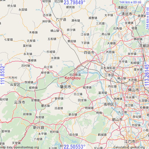
Kengkou GPS coordinates[2]
23° 9' 12.852" North, 112° 33' 29.952" East
| Map corner | latitude | longitude |
|---|---|---|
| Upper-left | 23.79849°, | 111.8552° |
| Center: | 23.15357°, | 112.55832° |
| Lower-right: | 22.50553°, | 113.26145° |
| Map W x H: | 143.8×143.8 km | = 89.4×89.4mi |
| max Lat: | 53.31946° ⇑93.7% North |
| Kengkou: | 23.15357° |
| min Lat: | ⇓6.3% South 18.22056° |
| min Long | Kengkou | max Long |
| 75.07348° | 112.55832° | 134.28917° |
| W 40.2%⇐ | ⇒59.8% E |
Elevation
Elevation of Kengkou is 4 m = 13 ft, and this is 480.8 m = 1577 ft below average elevation for this country.
| Max E: |
5622 m = 18445 ft | 98.3% |
| Avg. | 484.8 m = 1591 ft | |
| Kengkou | 4 m = 13 ft | |
Min E: |
-3 m = -10 ft | 1.7% |
See also: China elevation on elevation.city.
Geographical zone
Kengkou is located in North Torrid zone (between Equator and Tropic of Cancer). Distance of this Northern Tropic circle is 31.5 km =19.6 mi to North.| Distance of | km | miles | from Kengkou |
|---|---|---|---|
| North Pole | 7432.6 | 4618.4 | to North |
| Arctic Circle | 4826.7 | 2999.2 | to North |
| Tropic Cancer | 31.5 | 19.6 | to North |
| Equator | 2574.4 | 1599.7 | to South |


Nearby cities:
15 places around Kengkou: (largest is in red/bold)
• Chengbei
15.3 km =9.5 mi,  222°
222°
• Chengdong
14.9 km =9.3 mi, 215°
• Chengxi
16.6 km =10.3 mi, 221°
• Fenghuang
5.7 km =3.5 mi,  8°
8°
• Guangli
6.6 km =4.1 mi,  54°
54°
• Guicheng
4.5 km =2.8 mi,  15°
15°
• Huanggang
10 km =6.2 mi,  209°
209°
• Jindu
12.3 km =7.6 mi,  201°
201°
• Mugang
17.5 km =10.9 mi,  236°
236°
• Nan’an
17.5 km =10.9 mi, 218°
• Shapu
12.3 km =7.6 mi,  84°
84°
• Xiangang
16.5 km =10.3 mi,  137°
137°
• Xiaoxiang
17.7 km =11 mi,  264°
264°
• Yong’an
13.6 km =8.5 mi, 77°
• Zhaoqing
15.3 km =9.5 mi, 220°
Sources, notices
• [Note1] Compared only with cities in China existing in our database
• [Src1] Map data: © OpenStreetMap contributors (CC-BY-SA)
• [Src2] Other city data from geonames.org with taken over terms of usage.
• [Src3] Geographical zone / Annual Mean Temperature by Robert A. Rohde @ Wikipedia
