Baitu geodata
Baitu (Guangdong) is a seat of a fourth-order administrative division; located in China in Asia/Shanghai (GMT+8) time zone. In our database, there are 1268 cities with bigger population. Compared to other cities in China, 94.5% of cities are located further ↑North; 59.5% of cities are located further →East and 88.7% of cities have higher elevation than Baitu. Note1


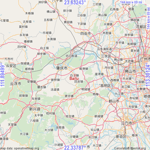
Baitu GPS coordinates[2]
22° 59' 12.12" North, 112° 35' 53.196" East
| Map corner | latitude | longitude |
|---|---|---|
| Upper-left | 23.63243°, | 111.89499° |
| Center: | 22.9867°, | 112.59811° |
| Lower-right: | 22.33787°, | 113.30124° |
| Map W x H: | 143.9×143.9 km | = 89.4×89.4mi |
| max Lat: | 53.31946° ⇑94.5% North |
| Baitu: | 22.9867° |
| min Lat: | ⇓5.5% South 18.22056° |
| min Long | Baitu | max Long |
| 75.07348° | 112.59811° | 134.28917° |
| W 40.5%⇐ | ⇒59.5% E |
Elevation
Elevation of Baitu is 11 m = 36 ft, and this is 473.8 m = 1554 ft below average elevation for this country.
| Max E: |
5622 m = 18445 ft | 88.7% |
| Avg. | 484.8 m = 1591 ft | |
| Baitu | 11 m = 36 ft | |
Min E: |
-3 m = -10 ft | 11.3% |
See also: China elevation on elevation.city.
Geographical zone
Baitu is located in North Torrid zone (between Equator and Tropic of Cancer). Distance of this Northern Tropic circle is 50 km =31.1 mi to North.| Distance of | km | miles | from Baitu |
|---|---|---|---|
| North Pole | 7451.2 | 4630 | to North |
| Arctic Circle | 4845.3 | 3010.7 | to North |
| Tropic Cancer | 50 | 31.1 | to North |
| Equator | 2555.9 | 1588.2 | to South |


Nearby cities:
15 places around Baitu: (largest is in red/bold)
• Chengbei
16 km =9.9 mi,  296°
296°
• Chengdong
14.1 km =8.8 mi, 296°
• Chengxi
16.4 km =10.2 mi,  292°
292°
• Gaoyao
16.2 km =10.1 mi,  284°
284°
• Huanggang
13.3 km =8.3 mi,  317°
317°
• Huilong
7.1 km =4.4 mi,  154°
154°
• Jiaotang
8.5 km =5.3 mi,  186°
186°
• Jindu
11.1 km =6.9 mi,  309°
309°
• Kengkou
19 km =11.8 mi,  347°
347°
• Liantang
15.3 km =9.5 mi,  256°
256°
• Mingcheng
17.3 km =10.7 mi, 145°
• Nan’an
15.8 km =9.8 mi, 288°
• Xiangang
9.6 km =6 mi,  47°
47°
• Xinqiao
19.6 km =12.2 mi, 259°
• Zhaoqing
15.7 km =9.8 mi, 296°
Sources, notices
• [Note1] Compared only with cities in China existing in our database
• [Src1] Map data: © OpenStreetMap contributors (CC-BY-SA)
• [Src2] Other city data from geonames.org with taken over terms of usage.
• [Src3] Geographical zone / Annual Mean Temperature by Robert A. Rohde @ Wikipedia
