Zhangxing geodata
Zhangxing (Shandong) is a seat of a fourth-order administrative division; located in China in Asia/Shanghai (GMT+8) time zone. In our database, there are 1268 cities with bigger population. Compared to other cities in China, 80.2% of cities are located further ↓South; 84.1% of cities are located further ←West and 75.3% of cities have higher elevation than Zhangxing. Note1


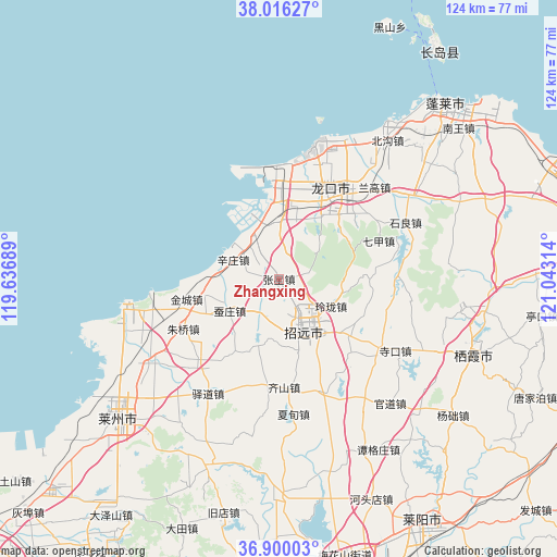
Zhangxing GPS coordinates[2]
37° 27' 36.828" North, 120° 20' 24.036" East
| Map corner | latitude | longitude |
|---|---|---|
| Upper-left | 38.01627°, | 119.63689° |
| Center: | 37.46023°, | 120.34001° |
| Lower-right: | 36.90003°, | 121.04314° |
| Map W x H: | 124.1×124.1 km | = 77.1×77.1mi |
| max Lat: | 53.31946° ⇑19.8% North |
| Zhangxing: | 37.46023° |
| min Lat: | ⇓80.2% South 18.22056° |
| min Long | Zhangxing | max Long |
| 75.07348° | 120.34001° | 134.28917° |
| W 84.1%⇐ | ⇒15.9% E |
Elevation
Elevation of Zhangxing is 36 m = 118 ft, and this is 448.8 m = 1472 ft below average elevation for this country.
| Max E: |
5622 m = 18445 ft | 75.3% |
| Avg. | 484.8 m = 1591 ft | |
| Zhangxing | 36 m = 118 ft | |
Min E: |
-3 m = -10 ft | 24.7% |
See also: China elevation on elevation.city.
Geographical zone
Zhangxing is located in North temperate zone (between Tropic of Cancer and the Arctic Circle). Distance of this Northern Tropic circle is 1559.3 km =968.9 mi to South.| Distance of | km | miles | from Zhangxing |
|---|---|---|---|
| North Pole | 5841.9 | 3630 | to North |
| Arctic Circle | 3236 | 2010.8 | to North |
| Tropic Cancer | 1559.3 | 968.9 | to South |
| Equator | 4165.2 | 2588.1 | to South |


Nearby cities:
15 places around Zhangxing: (largest is in red/bold)
• Beima
17 km =10.6 mi,  12°
12°
• Canzhuang
13.2 km =8.2 mi,  238°
238°
• Daqinjia
15.3 km =9.5 mi,  137°
137°
• Dongjiang
23.8 km =14.8 mi,  39°
39°
• Fushan
20.4 km =12.7 mi,  109°
109°
• Huangshanguan
10.9 km =6.8 mi,  328°
328°
• Jincheng
21.1 km =13.1 mi,  257°
257°
• Jinling
7.9 km =4.9 mi,  208°
208°
• Linglong
13 km =8.1 mi,  117°
117°
• Longgang
21.3 km =13.2 mi,  357°
357°
• Lutou
19.8 km =12.3 mi,  31°
31°
• Qijia
23.9 km =14.9 mi,  68°
68°
• Xiadingjia
16.2 km =10.1 mi,  57°
57°
• Xinzhuang
11.2 km =7 mi,  294°
294°
• Zhaoyuan
12.3 km =7.6 mi,  149°
149°
Sources, notices
• [Note1] Compared only with cities in China existing in our database
• [Src1] Map data: © OpenStreetMap contributors (CC-BY-SA)
• [Src2] Other city data from geonames.org with taken over terms of usage.
• [Src3] Geographical zone / Annual Mean Temperature by Robert A. Rohde @ Wikipedia
