Zhangjiazhuang geodata
Zhangjiazhuang (Hebei) is a seat of a fourth-order administrative division; located in China in Asia/Shanghai (GMT+8) time zone. In our database, there are 1268 cities with bigger population. Compared to other cities in China, 81.2% of cities are located further ↓South; 52.8% of cities are located further ←West and 67.2% of cities have higher elevation than Zhangjiazhuang. Note1


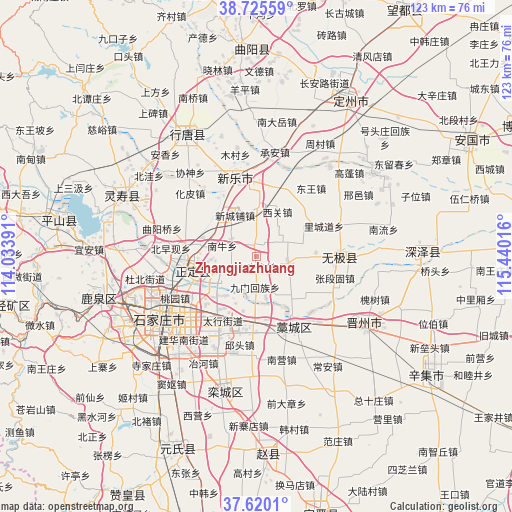
Zhangjiazhuang GPS coordinates[2]
38° 10' 29.784" North, 114° 44' 13.308" East
| Map corner | latitude | longitude |
|---|---|---|
| Upper-left | 38.72559°, | 114.03391° |
| Center: | 38.17494°, | 114.73703° |
| Lower-right: | 37.6201°, | 115.44016° |
| Map W x H: | 122.9×122.9 km | = 76.4×76.4mi |
| max Lat: | 53.31946° ⇑18.8% North |
| Zhangjiazhuang: | 38.17494° |
| min Lat: | ⇓81.2% South 18.22056° |
| min Long | Zhangjiazhuang | max Long |
| 75.07348° | 114.73703° | 134.28917° |
| W 52.8%⇐ | ⇒47.2% E |
Elevation
Elevation of Zhangjiazhuang is 64 m = 210 ft, and this is 420.8 m = 1381 ft below average elevation for this country.
| Max E: |
5622 m = 18445 ft | 67.2% |
| Avg. | 484.8 m = 1591 ft | |
| Zhangjiazhuang | 64 m = 210 ft | |
Min E: |
-3 m = -10 ft | 32.8% |
See also: China elevation on elevation.city.
Geographical zone
Zhangjiazhuang is located in North temperate zone (between Tropic of Cancer and the Arctic Circle). Distance of this Northern Tropic circle is 1638.7 km =1018.2 mi to South.| Distance of | km | miles | from Zhangjiazhuang |
|---|---|---|---|
| North Pole | 5762.4 | 3580.6 | to North |
| Arctic Circle | 3156.5 | 1961.4 | to North |
| Tropic Cancer | 1638.7 | 1018.2 | to South |
| Equator | 4244.7 | 2637.5 | to South |


Nearby cities:
15 places around Zhangjiazhuang: (largest is in red/bold)
• Beisu
6.5 km =4 mi,  110°
110°
• Donghoufang
14.1 km =8.8 mi,  86°
86°
• Gangshang
14.9 km =9.3 mi,  196°
196°
• Guozhuang
11.9 km =7.4 mi,  69°
69°
• Haozhuang
14.1 km =8.8 mi,  139°
139°
• Jiumen
7.5 km =4.7 mi,  184°
184°
• Nandong
8.2 km =5.1 mi,  166°
166°
• Nanmeng
4.8 km =3 mi,  44°
44°
• Nanniu
8.7 km =5.4 mi,  286°
286°
• Xiguan
12.1 km =7.5 mi,  25°
25°
• Xinchengpu
11.4 km =7.1 mi,  335°
335°
• Xin’an
12.7 km =7.9 mi,  296°
296°
• Xipingle
13.8 km =8.6 mi,  322°
322°
• Zengcun
7.8 km =4.8 mi,  359°
359°
• Zhufutun
8.1 km =5 mi,  256°
256°
Sources, notices
• [Note1] Compared only with cities in China existing in our database
• [Src1] Map data: © OpenStreetMap contributors (CC-BY-SA)
• [Src2] Other city data from geonames.org with taken over terms of usage.
• [Src3] Geographical zone / Annual Mean Temperature by Robert A. Rohde @ Wikipedia
