Xin’an geodata
Xin’an (Hebei) is a seat of a fourth-order administrative division; located in China in Asia/Shanghai (GMT+8) time zone. In our database, there are 1268 cities with bigger population. Compared to other cities in China, 81.3% of cities are located further ↓South; 52.1% of cities are located further ←West and 63.7% of cities have higher elevation than Xin’an. Note1


Xin’an GPS coordinates[2]
38° 13' 29.532" North, 114° 36' 24.66" East
| Map corner | latitude | longitude |
|---|---|---|
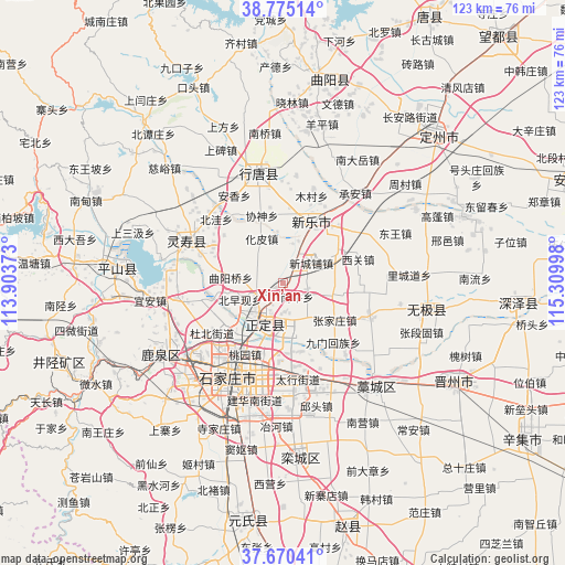
| Upper-left | 38.77514°, | 113.90373° |
| Center: | 38.22487°, | 114.60685° |
| Lower-right: | 37.67041°, | 115.30998° |
| Map W x H: | 122.8×122.8 km | = 76.3×76.3mi |
| max Lat: | 53.31946° ⇑18.7% North |
| Xin’an: | 38.22487° |
| min Lat: | ⇓81.3% South 18.22056° |
| min Long | Xin’an | max Long |
| 75.07348° | 114.60685° | 134.28917° |
| W 52.1%⇐ | ⇒47.9% E |
Elevation
Elevation of Xin’an is 79 m = 259 ft, and this is 405.8 m = 1331 ft below average elevation for this country.
| Max E: |
5622 m = 18445 ft | 63.7% |
| Avg. | 484.8 m = 1591 ft | |
| Xin’an | 79 m = 259 ft | |
Min E: |
-3 m = -10 ft | 36.3% |
See also: China elevation on elevation.city.
Geographical zone
Xin’an is located in North temperate zone (between Tropic of Cancer and the Arctic Circle). Distance of this Northern Tropic circle is 1644.3 km =1021.7 mi to South.| Distance of | km | miles | from Xin’an |
|---|---|---|---|
| North Pole | 5756.9 | 3577.2 | to North |
| Arctic Circle | 3151 | 1957.9 | to North |
| Tropic Cancer | 1644.3 | 1021.7 | to South |
| Equator | 4250.2 | 2641 | to South |


Nearby cities:
15 places around Xin’an: (largest is in red/bold)
• Beizaoxian
7.3 km =4.5 mi,  275°
275°
• Huapi
10.6 km =6.6 mi,  335°
335°
• Jiumen
17 km =10.6 mi,  140°
140°
• Nanlou
7.1 km =4.4 mi,  312°
312°
• Nanmeng
14.9 km =9.3 mi,  98°
98°
• Nanniu
4.3 km =2.7 mi, 136°
• Quyangqiao
11.4 km =7.1 mi, 276°
• Sanshengyuan
16.8 km =10.4 mi,  293°
293°
• Xieshen
15.1 km =9.4 mi, 342°
• Xinchengpu
8.2 km =5.1 mi,  54°
54°
• Xipingle
6.1 km =3.8 mi,  28°
28°
• Xizhaotong
17.1 km =10.6 mi,  182°
182°
• Zengcun
11.6 km =7.2 mi,  78°
78°
• Zhangjiazhuang
12.7 km =7.9 mi,  116°
116°
• Zhufutun
8.2 km =5.1 mi,  155°
155°
Sources, notices
• [Note1] Compared only with cities in China existing in our database
• [Src1] Map data: © OpenStreetMap contributors (CC-BY-SA)
• [Src2] Other city data from geonames.org with taken over terms of usage.
• [Src3] Geographical zone / Annual Mean Temperature by Robert A. Rohde @ Wikipedia
