Zaoyang geodata
Zaoyang (Hubei) is a populated place; located in China in Asia/Shanghai (GMT+8) time zone. With population of 184,509 people, there are 243 cities with bigger population in this country. Compared to other cities in China, 62% of cities are located further ↓South; 58.9% of cities are located further →East and 57.7% of cities have higher elevation than Zaoyang. Note1


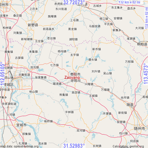
Zaoyang GPS coordinates[2]
32° 7' 37.992" North, 112° 45' 15.012" East
| Map corner | latitude | longitude |
|---|---|---|
| Upper-left | 32.72073°, | 112.05105° |
| Center: | 32.12722°, | 112.75417° |
| Lower-right: | 31.52983°, | 113.4573° |
| Map W x H: | 132.4×132.4 km | = 82.3×82.3mi |
| max Lat: | 53.31946° ⇑38% North |
| Zaoyang: | 32.12722° |
| min Lat: | ⇓62% South 18.22056° |
| min Long | Zaoyang | max Long |
| 75.07348° | 112.75417° | 134.28917° |
| W 41.1%⇐ | ⇒58.9% E |
Elevation
Elevation of Zaoyang is 113 m = 371 ft, and this is 371.8 m = 1220 ft below average elevation for this country.
| Max E: |
5622 m = 18445 ft | 57.7% |
| Avg. | 484.8 m = 1591 ft | |
| Zaoyang | 113 m = 371 ft | |
Min E: |
-3 m = -10 ft | 42.3% |
See also: Zaoyang elevation on elevation.city.
Geographical zone
Zaoyang is located in North temperate zone (between Tropic of Cancer and the Arctic Circle). Distance of this Northern Tropic circle is 966.3 km =600.4 mi to South.| Distance of | km | miles | from Zaoyang |
|---|---|---|---|
| North Pole | 6434.8 | 3998.4 | to North |
| Arctic Circle | 3829 | 2379.2 | to North |
| Tropic Cancer | 966.3 | 600.4 | to South |
| Equator | 3572.2 | 2219.7 | to South |


Nearby cities:
15 places around Zaoyang: (largest is in red/bold)
• Dongxiang
25.5 km =15.8 mi,  268°
268°
• Huanglong
32.9 km =20.4 mi,  238°
238°
• Juwan
17.5 km =10.9 mi, 241°
• Liusheng
19.6 km =12.2 mi,  82°
82°
• Lutou
21.1 km =13.1 mi,  51°
51°
• Qifang
19.9 km =12.4 mi,  295°
295°
• Taiping
17.7 km =11 mi,  0°
0°
• Wangcheng
25.5 km =15.8 mi,  137°
137°
• Wudian
16.1 km =10 mi,  174°
174°
• Wushan
29.9 km =18.6 mi,  87°
87°
• Xinglong
16.5 km =10.3 mi,  121°
121°
• Xinshi
30.4 km =18.9 mi,  40°
40°
• Xiongji
21.2 km =13.2 mi,  206°
206°
• Yangdang
23.4 km =14.5 mi,  331°
331°
• Zhangjiaji
30 km =18.6 mi, 265°
Sources, notices
• [Note1] Compared only with cities in China existing in our database
• [Src1] Map data: © OpenStreetMap contributors (CC-BY-SA)
• [Src2] Other city data from geonames.org with taken over terms of usage.
• [Src3] Geographical zone / Annual Mean Temperature by Robert A. Rohde @ Wikipedia
