Yunting geodata
Yunting (Jiangsu) is a seat of a fourth-order administrative division; located in China in Asia/Shanghai (GMT+8) time zone. In our database, there are 1268 cities with bigger population. Compared to other cities in China, 60.4% of cities are located further ↓South; 84.1% of cities are located further ←West and 87.7% of cities have higher elevation than Yunting. Note1


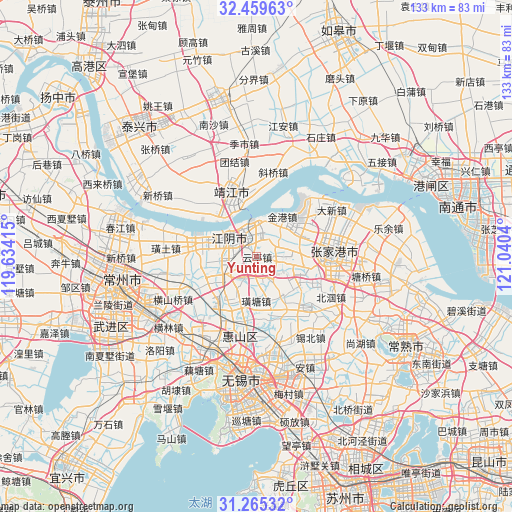
Yunting GPS coordinates[2]
31° 51' 51.876" North, 120° 20' 14.172" East
| Map corner | latitude | longitude |
|---|---|---|
| Upper-left | 32.45963°, | 119.63415° |
| Center: | 31.86441°, | 120.33727° |
| Lower-right: | 31.26532°, | 121.0404° |
| Map W x H: | 132.8×132.8 km | = 82.5×82.5mi |
| max Lat: | 53.31946° ⇑39.6% North |
| Yunting: | 31.86441° |
| min Lat: | ⇓60.4% South 18.22056° |
| min Long | Yunting | max Long |
| 75.07348° | 120.33727° | 134.28917° |
| W 84.1%⇐ | ⇒15.9% E |
Elevation
Elevation of Yunting is 12 m = 39 ft, and this is 472.8 m = 1551 ft below average elevation for this country.
| Max E: |
5622 m = 18445 ft | 87.7% |
| Avg. | 484.8 m = 1591 ft | |
| Yunting | 12 m = 39 ft | |
Min E: |
-3 m = -10 ft | 12.3% |
See also: China elevation on elevation.city.
Geographical zone
Yunting is located in North temperate zone (between Tropic of Cancer and the Arctic Circle). Distance of this Northern Tropic circle is 937.1 km =582.3 mi to South.| Distance of | km | miles | from Yunting |
|---|---|---|---|
| North Pole | 6464.1 | 4016.6 | to North |
| Arctic Circle | 3858.2 | 2397.4 | to North |
| Tropic Cancer | 937.1 | 582.3 | to South |
| Equator | 3543 | 2201.5 | to South |


Nearby cities:
15 places around Yunting: (largest is in red/bold)
• Changjing
18 km =11.2 mi,  132°
132°
• Huashi
12.4 km =7.7 mi,  105°
105°
• Jiangyin
8.7 km =5.4 mi,  306°
306°
• Jingang
11.7 km =7.3 mi,  30°
30°
• Jingjiang
18.1 km =11.2 mi,  337°
337°
• Nanzha
9.1 km =5.7 mi,  263°
263°
• Qingyang
13.7 km =8.5 mi,  216°
216°
• Shengang
18.9 km =11.7 mi,  277°
277°
• Xiagang
12.5 km =7.8 mi,  286°
286°
• Xinqiao
17.3 km =10.7 mi, 113°
• Xuxiake
11.3 km =7 mi,  179°
179°
• Yaosai
6.9 km =4.3 mi, 311°
• Yuecheng
11 km =6.8 mi,  238°
238°
• Zhouzhuang
6.3 km =3.9 mi,  87°
87°
• Zhutang
12.5 km =7.8 mi,  147°
147°
Sources, notices
• [Note1] Compared only with cities in China existing in our database
• [Src1] Map data: © OpenStreetMap contributors (CC-BY-SA)
• [Src2] Other city data from geonames.org with taken over terms of usage.
• [Src3] Geographical zone / Annual Mean Temperature by Robert A. Rohde @ Wikipedia
