Qingyang geodata
Qingyang (Jiangsu) is a seat of a fourth-order administrative division; located in China in Asia/Shanghai (GMT+8) time zone. In our database, there are 1268 cities with bigger population. Compared to other cities in China, 59.9% of cities are located further ↓South; 83.6% of cities are located further ←West and 95.9% of cities have higher elevation than Qingyang. Note1


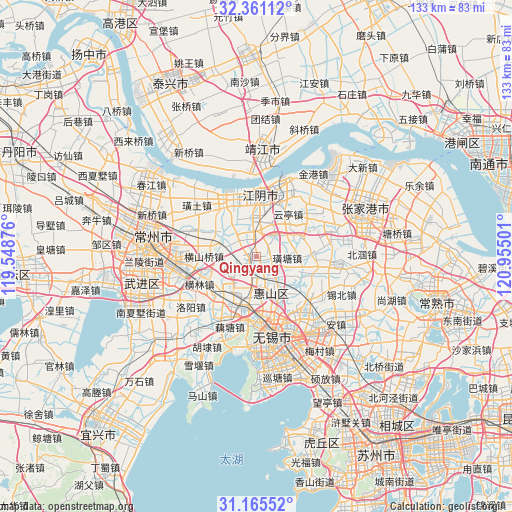
Qingyang GPS coordinates[2]
31° 45' 54.9" North, 120° 15' 6.768" East
| Map corner | latitude | longitude |
|---|---|---|
| Upper-left | 32.36112°, | 119.54876° |
| Center: | 31.76525°, | 120.25188° |
| Lower-right: | 31.16552°, | 120.95501° |
| Map W x H: | 132.9×132.9 km | = 82.6×82.6mi |
| max Lat: | 53.31946° ⇑40.1% North |
| Qingyang: | 31.76525° |
| min Lat: | ⇓59.9% South 18.22056° |
| min Long | Qingyang | max Long |
| 75.07348° | 120.25188° | 134.28917° |
| W 83.6%⇐ | ⇒16.4% E |
Elevation
Elevation of Qingyang is 6 m = 20 ft, and this is 478.8 m = 1571 ft below average elevation for this country.
| Max E: |
5622 m = 18445 ft | 95.9% |
| Avg. | 484.8 m = 1591 ft | |
| Qingyang | 6 m = 20 ft | |
Min E: |
-3 m = -10 ft | 4.1% |
See also: China elevation on elevation.city.
Geographical zone
Qingyang is located in North temperate zone (between Tropic of Cancer and the Arctic Circle). Distance of this Northern Tropic circle is 926 km =575.4 mi to South.| Distance of | km | miles | from Qingyang |
|---|---|---|---|
| North Pole | 6475.1 | 4023.4 | to North |
| Arctic Circle | 3869.2 | 2404.2 | to North |
| Tropic Cancer | 926 | 575.4 | to South |
| Equator | 3532 | 2194.7 | to South |


Nearby cities:
15 places around Qingyang: (largest is in red/bold)
• Henglin
16.5 km =10.3 mi,  243°
243°
• Hengshanqiao
13.3 km =8.3 mi,  269°
269°
• Jiangyin
16.2 km =10.1 mi,  3°
3°
• Liutan
16.6 km =10.3 mi,  166°
166°
• Luoshe
15 km =9.3 mi,  206°
206°
• Nanzha
10.1 km =6.3 mi,  354°
354°
• Qianzhou
8.9 km =5.5 mi,  204°
204°
• Xiagang
15.1 km =9.4 mi,  344°
344°
• Xuxiake
8.1 km =5 mi,  92°
92°
• Yanqiao
8.8 km =5.5 mi,  163°
163°
• Yaosai
15.8 km =9.8 mi,  10°
10°
• Yuecheng
5.4 km =3.4 mi, 346°
• Yunting
13.7 km =8.5 mi,  36°
36°
• Yuqi
8.4 km =5.2 mi,  230°
230°
• Zhutang
14.8 km =9.2 mi, 88°
Sources, notices
• [Note1] Compared only with cities in China existing in our database
• [Src1] Map data: © OpenStreetMap contributors (CC-BY-SA)
• [Src2] Other city data from geonames.org with taken over terms of usage.
• [Src3] Geographical zone / Annual Mean Temperature by Robert A. Rohde @ Wikipedia
