Yulindian geodata
Yulindian (Shandong) is a seat of a fourth-order administrative division; located in China in Asia/Shanghai (GMT+8) time zone. In our database, there are 1268 cities with bigger population. Compared to other cities in China, 79.7% of cities are located further ↓South; 90.4% of cities are located further ←West and 68.7% of cities have higher elevation than Yulindian. Note1


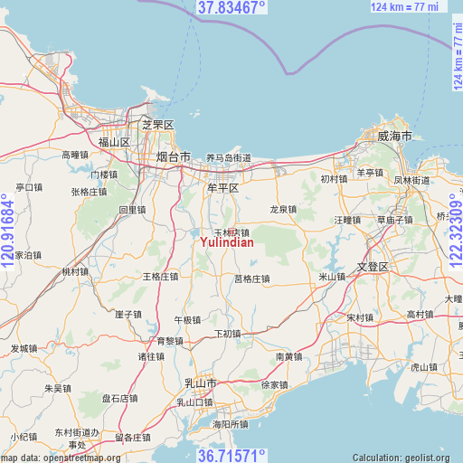
Yulindian GPS coordinates[2]
37° 16' 38.172" North, 121° 37' 11.856" East
| Map corner | latitude | longitude |
|---|---|---|
| Upper-left | 37.83467°, | 120.91684° |
| Center: | 37.27727°, | 121.61996° |
| Lower-right: | 36.71571°, | 122.32309° |
| Map W x H: | 124.4×124.4 km | = 77.3×77.3mi |
| max Lat: | 53.31946° ⇑20.3% North |
| Yulindian: | 37.27727° |
| min Lat: | ⇓79.7% South 18.22056° |
| min Long | Yulindian | max Long |
| 75.07348° | 121.61996° | 134.28917° |
| W 90.4%⇐ | ⇒9.6% E |
Elevation
Elevation of Yulindian is 57 m = 187 ft, and this is 427.8 m = 1404 ft below average elevation for this country.
| Max E: |
5622 m = 18445 ft | 68.7% |
| Avg. | 484.8 m = 1591 ft | |
| Yulindian | 57 m = 187 ft | |
Min E: |
-3 m = -10 ft | 31.3% |
See also: China elevation on elevation.city.
Geographical zone
Yulindian is located in North temperate zone (between Tropic of Cancer and the Arctic Circle). Distance of this Northern Tropic circle is 1538.9 km =956.2 mi to South.| Distance of | km | miles | from Yulindian |
|---|---|---|---|
| North Pole | 5862.2 | 3642.6 | to North |
| Arctic Circle | 3256.3 | 2023.4 | to North |
| Tropic Cancer | 1538.9 | 956.2 | to South |
| Equator | 4144.8 | 2575.5 | to South |


Nearby cities:
15 places around Yulindian: (largest is in red/bold)
• Dayao
12.9 km =8 mi,  14°
14°
• Gaoling
8.8 km =5.5 mi,  282°
282°
• Gejia
24.7 km =15.3 mi,  124°
124°
• Jianggezhuang
23.1 km =14.4 mi,  48°
48°
• Jiejiazhuang
17.4 km =10.8 mi,  317°
317°
• Jieshi
21.8 km =13.5 mi,  90°
90°
• Jugezhuang
13.5 km =8.4 mi,  155°
155°
• Laishan
24.7 km =15.3 mi,  301°
301°
• Longquan
14.8 km =9.2 mi,  65°
65°
• Ninghai
11.9 km =7.4 mi,  355°
355°
• Shuidao
12.4 km =7.7 mi,  197°
197°
• Wanggezhuang
22.7 km =14.1 mi,  238°
238°
• Wenhua
12.9 km =8 mi,  348°
348°
• Wuning
11.6 km =7.2 mi,  330°
330°
• Yangmadao
20 km =12.4 mi, 357°
Sources, notices
• [Note1] Compared only with cities in China existing in our database
• [Src1] Map data: © OpenStreetMap contributors (CC-BY-SA)
• [Src2] Other city data from geonames.org with taken over terms of usage.
• [Src3] Geographical zone / Annual Mean Temperature by Robert A. Rohde @ Wikipedia
