Shuidao geodata
Shuidao (Shandong) is a seat of a fourth-order administrative division; located in China in Asia/Shanghai (GMT+8) time zone. In our database, there are 1268 cities with bigger population. Compared to other cities in China, 79.6% of cities are located further ↓South; 90.2% of cities are located further ←West and 62.1% of cities have higher elevation than Shuidao. Note1


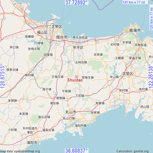
Shuidao GPS coordinates[2]
37° 10' 14.592" North, 121° 34' 41.7" East
| Map corner | latitude | longitude |
|---|---|---|
| Upper-left | 37.72892°, | 120.87513° |
| Center: | 37.17072°, | 121.57825° |
| Lower-right: | 36.60837°, | 122.28138° |
| Map W x H: | 124.6×124.6 km | = 77.4×77.4mi |
| max Lat: | 53.31946° ⇑20.4% North |
| Shuidao: | 37.17072° |
| min Lat: | ⇓79.6% South 18.22056° |
| min Long | Shuidao | max Long |
| 75.07348° | 121.57825° | 134.28917° |
| W 90.2%⇐ | ⇒9.8% E |
Elevation
Elevation of Shuidao is 87 m = 285 ft, and this is 397.8 m = 1305 ft below average elevation for this country.
| Max E: |
5622 m = 18445 ft | 62.1% |
| Avg. | 484.8 m = 1591 ft | |
| Shuidao | 87 m = 285 ft | |
Min E: |
-3 m = -10 ft | 37.9% |
See also: China elevation on elevation.city.
Geographical zone
Shuidao is located in North temperate zone (between Tropic of Cancer and the Arctic Circle). Distance of this Northern Tropic circle is 1527.1 km =948.9 mi to South.| Distance of | km | miles | from Shuidao |
|---|---|---|---|
| North Pole | 5874.1 | 3650 | to North |
| Arctic Circle | 3268.2 | 2030.8 | to North |
| Tropic Cancer | 1527.1 | 948.9 | to South |
| Equator | 4133 | 2568.1 | to South |


Nearby cities:
15 places around Shuidao: (largest is in red/bold)
• Dayao
25.3 km =15.7 mi,  15°
15°
• Fengjia
17.3 km =10.7 mi,  151°
151°
• Gaoling
14.6 km =9.1 mi,  340°
340°
• Gejia
24.3 km =15.1 mi,  94°
94°
• Jiejiazhuang
26 km =16.2 mi, 342°
• Jieshi
28 km =17.4 mi,  65°
65°
• Jugezhuang
9.3 km =5.8 mi, 92°
• Longquan
24.9 km =15.5 mi,  43°
43°
• Ninghai
23.9 km =14.9 mi,  6°
6°
• Wanggezhuang
15.6 km =9.7 mi,  269°
269°
• Wenhua
24.5 km =15.2 mi,  2°
2°
• Wuji
14.3 km =8.9 mi,  215°
215°
• Wuning
22 km =13.7 mi,  354°
354°
• Xiachu
15.5 km =9.6 mi,  170°
170°
• Yulindian
12.4 km =7.7 mi, 17°
Sources, notices
• [Note1] Compared only with cities in China existing in our database
• [Src1] Map data: © OpenStreetMap contributors (CC-BY-SA)
• [Src2] Other city data from geonames.org with taken over terms of usage.
• [Src3] Geographical zone / Annual Mean Temperature by Robert A. Rohde @ Wikipedia
