Yuanyi geodata
Yuanyi (Chongqing) is a seat of a fourth-order administrative division; located in China in Asia/Shanghai (GMT+8) time zone. In our database, there are 1268 cities with bigger population. Compared to other cities in China, 52.4% of cities are located further ↓South; 82.1% of cities are located further →East and 71.6% of cities have lower elevation than Yuanyi. Note1


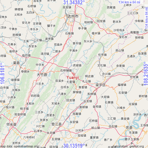
Yuanyi GPS coordinates[2]
30° 44' 29.04" North, 107° 30' 47.592" East
| Map corner | latitude | longitude |
|---|---|---|
| Upper-left | 31.34382°, | 106.8101° |
| Center: | 30.7414°, | 107.51322° |
| Lower-right: | 30.13519°, | 108.21635° |
| Map W x H: | 134.4×134.4 km | = 83.5×83.5mi |
| max Lat: | 53.31946° ⇑47.6% North |
| Yuanyi: | 30.7414° |
| min Lat: | ⇓52.4% South 18.22056° |
| min Long | Yuanyi | max Long |
| 75.07348° | 107.51322° | 134.28917° |
| W 17.9%⇐ | ⇒82.1% E |
Elevation
Elevation of Yuanyi is 441 m = 1447 ft, and this is 43.8 m = 144 ft below average elevation for this country.
| Max E: |
5622 m = 18445 ft | 28.4% |
| Avg. | 484.8 m = 1591 ft | |
| Yuanyi | 441 m = 1447 ft | |
Min E: |
-3 m = -10 ft | 71.6% |
See also: China elevation on elevation.city.
Geographical zone
Yuanyi is located in North temperate zone (between Tropic of Cancer and the Arctic Circle). Distance of this Northern Tropic circle is 812.2 km =504.7 mi to South.| Distance of | km | miles | from Yuanyi |
|---|---|---|---|
| North Pole | 6588.9 | 4094.2 | to North |
| Arctic Circle | 3983.1 | 2475 | to North |
| Tropic Cancer | 812.2 | 504.7 | to South |
| Equator | 3418.1 | 2123.9 | to South |


Nearby cities:
15 places around Yuanyi: (largest is in red/bold)
• Ansheng
20.6 km =12.8 mi,  105°
105°
• Bishan
6.3 km =3.9 mi,  301°
301°
• Hucheng
8.6 km =5.3 mi,  18°
18°
• Jindai
23.5 km =14.6 mi,  131°
131°
• Jukui
14.2 km =8.8 mi,  145°
145°
• Lirang
12.9 km =8 mi,  119°
119°
• Longmen
17.8 km =11.1 mi,  69°
69°
• Longsheng
5.2 km =3.2 mi,  42°
42°
• Mingda
13.9 km =8.6 mi,  96°
96°
• Pingjin
14.7 km =9.1 mi,  168°
168°
• Qixing
7.4 km =4.6 mi,  203°
203°
• Renxian
18.2 km =11.3 mi, 119°
• Xinsheng
23.1 km =14.4 mi,  60°
60°
• Yinping
23 km =14.3 mi, 165°
• Zhushan
6.4 km =4 mi, 114°
Sources, notices
• [Note1] Compared only with cities in China existing in our database
• [Src1] Map data: © OpenStreetMap contributors (CC-BY-SA)
• [Src2] Other city data from geonames.org with taken over terms of usage.
• [Src3] Geographical zone / Annual Mean Temperature by Robert A. Rohde @ Wikipedia
