Lirang geodata
Lirang (Chongqing) is a seat of a fourth-order administrative division; located in China in Asia/Shanghai (GMT+8) time zone. In our database, there are 1268 cities with bigger population. Compared to other cities in China, 52% of cities are located further ↓South; 81.8% of cities are located further →East and 72.2% of cities have lower elevation than Lirang. Note1


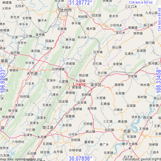
Lirang GPS coordinates[2]
30° 41' 5.784" North, 107° 37' 53.22" East
| Map corner | latitude | longitude |
|---|---|---|
| Upper-left | 31.28772°, | 106.92833° |
| Center: | 30.68494°, | 107.63145° |
| Lower-right: | 30.07838°, | 108.33458° |
| Map W x H: | 134.5×134.5 km | = 83.6×83.6mi |
| max Lat: | 53.31946° ⇑48% North |
| Lirang: | 30.68494° |
| min Lat: | ⇓52% South 18.22056° |
| min Long | Lirang | max Long |
| 75.07348° | 107.63145° | 134.28917° |
| W 18.2%⇐ | ⇒81.8% E |
Elevation
Elevation of Lirang is 457 m = 1499 ft, and this is 27.8 m = 91 ft below average elevation for this country.
| Max E: |
5622 m = 18445 ft | 27.8% |
| Avg. | 484.8 m = 1591 ft | |
| Lirang | 457 m = 1499 ft | |
Min E: |
-3 m = -10 ft | 72.2% |
See also: China elevation on elevation.city.
Geographical zone
Lirang is located in North temperate zone (between Tropic of Cancer and the Arctic Circle). Distance of this Northern Tropic circle is 805.9 km =500.8 mi to South.| Distance of | km | miles | from Lirang |
|---|---|---|---|
| North Pole | 6595.2 | 4098.1 | to North |
| Arctic Circle | 3989.3 | 2478.8 | to North |
| Tropic Cancer | 805.9 | 500.8 | to South |
| Equator | 3411.8 | 2120 | to South |


Nearby cities:
15 places around Lirang: (largest is in red/bold)
• Ansheng
8.6 km =5.3 mi,  86°
86°
• Chengbei
15.2 km =9.4 mi,  74°
74°
• Helin
12.5 km =7.8 mi,  157°
157°
• Hucheng
16.8 km =10.4 mi,  329°
329°
• Jindai
11.2 km =7 mi,  145°
145°
• Jukui
6.4 km =4 mi,  211°
211°
• Longmen
13.7 km =8.5 mi,  22°
22°
• Longsheng
12.7 km =7.9 mi,  322°
322°
• Mingda
5.2 km =3.2 mi,  28°
28°
• Pingjin
11.6 km =7.2 mi,  225°
225°
• Qixing
14.3 km =8.9 mi,  267°
267°
• Renxian
5.3 km =3.3 mi,  120°
120°
• Yinping
16.8 km =10.4 mi,  198°
198°
• Yuanyi
12.9 km =8 mi,  299°
299°
• Zhushan
6.5 km =4 mi, 303°
Sources, notices
• [Note1] Compared only with cities in China existing in our database
• [Src1] Map data: © OpenStreetMap contributors (CC-BY-SA)
• [Src2] Other city data from geonames.org with taken over terms of usage.
• [Src3] Geographical zone / Annual Mean Temperature by Robert A. Rohde @ Wikipedia
