Picheng geodata
Picheng (Jiangsu) is a seat of a fourth-order administrative division; located in China in Asia/Shanghai (GMT+8) time zone. In our database, there are 1268 cities with bigger population. Compared to other cities in China, 61.9% of cities are located further ↓South; 80% of cities are located further ←West and 91.2% of cities have higher elevation than Picheng. Note1


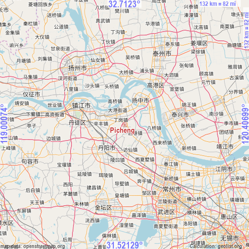
Picheng GPS coordinates[2]
32° 7' 7.464" North, 119° 42' 13.896" East
| Map corner | latitude | longitude |
|---|---|---|
| Upper-left | 32.7123°, | 119.00074° |
| Center: | 32.11874°, | 119.70386° |
| Lower-right: | 31.52129°, | 120.40699° |
| Map W x H: | 132.4×132.4 km | = 82.3×82.3mi |
| max Lat: | 53.31946° ⇑38.1% North |
| Picheng: | 32.11874° |
| min Lat: | ⇓61.9% South 18.22056° |
| min Long | Picheng | max Long |
| 75.07348° | 119.70386° | 134.28917° |
| W 80%⇐ | ⇒20% E |
Elevation
Elevation of Picheng is 9 m = 30 ft, and this is 475.8 m = 1561 ft below average elevation for this country.
| Max E: |
5622 m = 18445 ft | 91.2% |
| Avg. | 484.8 m = 1591 ft | |
| Picheng | 9 m = 30 ft | |
Min E: |
-3 m = -10 ft | 8.8% |
See also: China elevation on elevation.city.
Geographical zone
Picheng is located in North temperate zone (between Tropic of Cancer and the Arctic Circle). Distance of this Northern Tropic circle is 965.4 km =599.9 mi to South.| Distance of | km | miles | from Picheng |
|---|---|---|---|
| North Pole | 6435.8 | 3999 | to North |
| Arctic Circle | 3829.9 | 2379.8 | to North |
| Tropic Cancer | 965.4 | 599.9 | to South |
| Equator | 3571.3 | 2219.1 | to South |


Nearby cities:
15 places around Picheng: (largest is in red/bold)
• Baqiao
16.1 km =10 mi,  93°
93°
• Dagang
9.4 km =5.8 mi,  330°
330°
• Dalu
11.1 km =6.9 mi,  14°
14°
• Dinggang
3.3 km =2.1 mi, 327°
• Fangxian
13.4 km =8.3 mi,  167°
167°
• Gaoqiao
13.3 km =8.3 mi,  337°
337°
• Houxiang
5.7 km =3.5 mi,  107°
107°
• Jiepai
15 km =9.3 mi, 109°
• Sanmao
17 km =10.6 mi,  38°
38°
• Xinba
16.8 km =10.4 mi,  16°
16°
• Xinfeng
13 km =8.1 mi,  267°
267°
• Xinglong
15 km =9.3 mi,  64°
64°
• Xinqiao
10.8 km =6.7 mi,  117°
117°
• Yaoqiao
8.1 km =5 mi,  52°
52°
• Youfang
13.3 km =8.3 mi, 85°
Sources, notices
• [Note1] Compared only with cities in China existing in our database
• [Src1] Map data: © OpenStreetMap contributors (CC-BY-SA)
• [Src2] Other city data from geonames.org with taken over terms of usage.
• [Src3] Geographical zone / Annual Mean Temperature by Robert A. Rohde @ Wikipedia
