Dalu geodata
Dalu (Jiangsu) is a seat of a fourth-order administrative division; located in China in Asia/Shanghai (GMT+8) time zone. In our database, there are 1268 cities with bigger population. Compared to other cities in China, 62.5% of cities are located further ↓South; 80.1% of cities are located further ←West and 95.9% of cities have higher elevation than Dalu. Note1


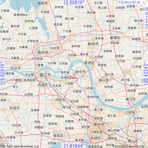
Dalu GPS coordinates[2]
32° 12' 54.936" North, 119° 43' 56.28" East
| Map corner | latitude | longitude |
|---|---|---|
| Upper-left | 32.80819°, | 119.02918° |
| Center: | 32.21526°, | 119.7323° |
| Lower-right: | 31.61844°, | 120.43543° |
| Map W x H: | 132.3×132.3 km | = 82.2×82.2mi |
| max Lat: | 53.31946° ⇑37.5% North |
| Dalu: | 32.21526° |
| min Lat: | ⇓62.5% South 18.22056° |
| min Long | Dalu | max Long |
| 75.07348° | 119.7323° | 134.28917° |
| W 80.1%⇐ | ⇒19.9% E |
Elevation
Elevation of Dalu is 6 m = 20 ft, and this is 478.8 m = 1571 ft below average elevation for this country.
| Max E: |
5622 m = 18445 ft | 95.9% |
| Avg. | 484.8 m = 1591 ft | |
| Dalu | 6 m = 20 ft | |
Min E: |
-3 m = -10 ft | 4.1% |
See also: China elevation on elevation.city.
Geographical zone
Dalu is located in North temperate zone (between Tropic of Cancer and the Arctic Circle). Distance of this Northern Tropic circle is 976.1 km =606.5 mi to South.| Distance of | km | miles | from Dalu |
|---|---|---|---|
| North Pole | 6425.1 | 3992.4 | to North |
| Arctic Circle | 3819.2 | 2373.1 | to North |
| Tropic Cancer | 976.1 | 606.5 | to South |
| Equator | 3582 | 2225.8 | to South |


Nearby cities:
15 places around Dalu: (largest is in red/bold)
• Dagang
7.7 km =4.8 mi,  250°
250°
• Daqiao
17.4 km =10.8 mi,  351°
351°
• Dinggang
9.1 km =5.7 mi,  209°
209°
• Gaoqiao
8 km =5 mi,  281°
281°
• Houxiang
12.8 km =8 mi,  167°
167°
• Kou’an
17 km =10.6 mi,  52°
52°
• Minggou
16.9 km =10.5 mi,  77°
77°
• Picheng
11.1 km =6.9 mi,  194°
194°
• Sanmao
8.3 km =5.2 mi,  71°
71°
• Xinba
5.7 km =3.5 mi,  20°
20°
• Xinba
13.8 km =8.6 mi,  301°
301°
• Xinglong
11.6 km =7.2 mi,  110°
110°
• Xinqiao
17.1 km =10.6 mi,  156°
156°
• Yaoqiao
6.9 km =4.3 mi,  146°
146°
• Youfang
14.3 km =8.9 mi,  132°
132°
Sources, notices
• [Note1] Compared only with cities in China existing in our database
• [Src1] Map data: © OpenStreetMap contributors (CC-BY-SA)
• [Src2] Other city data from geonames.org with taken over terms of usage.
• [Src3] Geographical zone / Annual Mean Temperature by Robert A. Rohde @ Wikipedia
