Yongxing geodata
Yongxing (Jiangsu) is a seat of a fourth-order administrative division; located in China in Asia/Shanghai (GMT+8) time zone. In our database, there are 1268 cities with bigger population. Compared to other cities in China, 60.7% of cities are located further ↓South; 87.4% of cities are located further ←West and 98.3% of cities have higher elevation than Yongxing. Note1


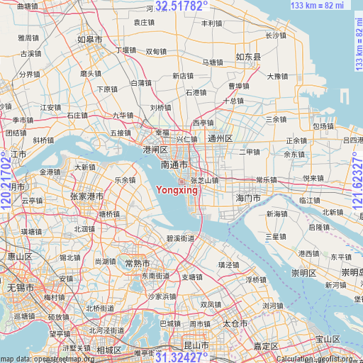
Yongxing GPS coordinates[2]
31° 55' 22.728" North, 120° 55' 12.504" East
| Map corner | latitude | longitude |
|---|---|---|
| Upper-left | 32.51782°, | 120.21702° |
| Center: | 31.92298°, | 120.92014° |
| Lower-right: | 31.32427°, | 121.62327° |
| Map W x H: | 132.7×132.7 km | = 82.5×82.5mi |
| max Lat: | 53.31946° ⇑39.3% North |
| Yongxing: | 31.92298° |
| min Lat: | ⇓60.7% South 18.22056° |
| min Long | Yongxing | max Long |
| 75.07348° | 120.92014° | 134.28917° |
| W 87.4%⇐ | ⇒12.6% E |
Elevation
Elevation of Yongxing is 4 m = 13 ft, and this is 480.8 m = 1577 ft below average elevation for this country.
| Max E: |
5622 m = 18445 ft | 98.3% |
| Avg. | 484.8 m = 1591 ft | |
| Yongxing | 4 m = 13 ft | |
Min E: |
-3 m = -10 ft | 1.7% |
See also: China elevation on elevation.city.
Geographical zone
Yongxing is located in North temperate zone (between Tropic of Cancer and the Arctic Circle). Distance of this Northern Tropic circle is 943.6 km =586.3 mi to South.| Distance of | km | miles | from Yongxing |
|---|---|---|---|
| North Pole | 6457.6 | 4012.6 | to North |
| Arctic Circle | 3851.7 | 2393.3 | to North |
| Tropic Cancer | 943.6 | 586.3 | to South |
| Equator | 3549.5 | 2205.6 | to South |


Nearby cities:
15 places around Yongxing: (largest is in red/bold)
• Chuangang
13.6 km =8.5 mi,  87°
87°
• Guanyinshan
9.7 km =6 mi,  7°
7°
• Jiangzao
13.4 km =8.3 mi,  52°
52°
• Langshan
5 km =3.1 mi,  319°
319°
• Nantong
12.7 km =7.9 mi,  340°
340°
• Qinzao
16.6 km =10.3 mi, 340°
• Rengang
12.6 km =7.8 mi, 320°
• Tianbu
18.3 km =11.4 mi, 88°
• Xianfeng
11.2 km =7 mi,  29°
29°
• Xiaohai
5.6 km =3.5 mi, 51°
• Xingdong
18.3 km =11.4 mi, 14°
• Xingren
15.9 km =9.9 mi, 6°
• Xinkai
1.8 km =1.1 mi,  124°
124°
• Zhangzhishan
8.1 km =5 mi, 86°
• Zhuhang
6.4 km =4 mi,  113°
113°
Sources, notices
• [Note1] Compared only with cities in China existing in our database
• [Src1] Map data: © OpenStreetMap contributors (CC-BY-SA)
• [Src2] Other city data from geonames.org with taken over terms of usage.
• [Src3] Geographical zone / Annual Mean Temperature by Robert A. Rohde @ Wikipedia
