Xianfeng geodata
Xianfeng (Jiangsu) is a seat of a fourth-order administrative division; located in China in Asia/Shanghai (GMT+8) time zone. In our database, there are 1268 cities with bigger population. Compared to other cities in China, 61.2% of cities are located further ↓South; 87.7% of cities are located further ←West and 97.2% of cities have higher elevation than Xianfeng. Note1


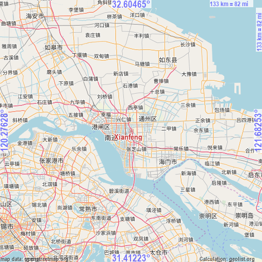
Xianfeng GPS coordinates[2]
32° 0' 37.368" North, 120° 58' 45.84" East
| Map corner | latitude | longitude |
|---|---|---|
| Upper-left | 32.60465°, | 120.27628° |
| Center: | 32.01038°, | 120.9794° |
| Lower-right: | 31.41223°, | 121.68253° |
| Map W x H: | 132.6×132.6 km | = 82.4×82.4mi |
| max Lat: | 53.31946° ⇑38.8% North |
| Xianfeng: | 32.01038° |
| min Lat: | ⇓61.2% South 18.22056° |
| min Long | Xianfeng | max Long |
| 75.07348° | 120.9794° | 134.28917° |
| W 87.7%⇐ | ⇒12.3% E |
Elevation
Elevation of Xianfeng is 5 m = 16 ft, and this is 479.8 m = 1574 ft below average elevation for this country.
| Max E: |
5622 m = 18445 ft | 97.2% |
| Avg. | 484.8 m = 1591 ft | |
| Xianfeng | 5 m = 16 ft | |
Min E: |
-3 m = -10 ft | 2.8% |
See also: China elevation on elevation.city.
Geographical zone
Xianfeng is located in North temperate zone (between Tropic of Cancer and the Arctic Circle). Distance of this Northern Tropic circle is 953.3 km =592.4 mi to South.| Distance of | km | miles | from Xianfeng |
|---|---|---|---|
| North Pole | 6447.8 | 4006.5 | to North |
| Arctic Circle | 3842 | 2387.3 | to North |
| Tropic Cancer | 953.3 | 592.4 | to South |
| Equator | 3559.2 | 2211.6 | to South |


Nearby cities:
15 places around Xianfeng: (largest is in red/bold)
• Chuangang
12.1 km =7.5 mi,  139°
139°
• Guanyinshan
4.3 km =2.7 mi,  268°
268°
• Jiangzao
5.2 km =3.2 mi,  106°
106°
• Jinsha
12.5 km =7.8 mi,  45°
45°
• Langshan
10.7 km =6.6 mi,  236°
236°
• Nantong
10.1 km =6.3 mi,  282°
282°
• Qinzao
12.5 km =7.8 mi,  298°
298°
• Xiaohai
6.3 km =3.9 mi,  190°
190°
• Xingdong
8.1 km =5 mi,  352°
352°
• Xingren
7.1 km =4.4 mi,  328°
328°
• Xinkai
11.5 km =7.1 mi,  201°
201°
• Xiting
12.3 km =7.6 mi,  11°
11°
• Yongxing
11.2 km =7 mi,  209°
209°
• Zhangzhishan
9.6 km =6 mi,  164°
164°
• Zhuhang
12.3 km =7.6 mi,  178°
178°
Sources, notices
• [Note1] Compared only with cities in China existing in our database
• [Src1] Map data: © OpenStreetMap contributors (CC-BY-SA)
• [Src2] Other city data from geonames.org with taken over terms of usage.
• [Src3] Geographical zone / Annual Mean Temperature by Robert A. Rohde @ Wikipedia
