Xiaohai geodata
Xiaohai (Jiangsu) is a seat of a fourth-order administrative division; located in China in Asia/Shanghai (GMT+8) time zone. In our database, there are 1268 cities with bigger population. Compared to other cities in China, 60.9% of cities are located further ↓South; 87.6% of cities are located further ←West and 99.4% of cities have higher elevation than Xiaohai. Note1


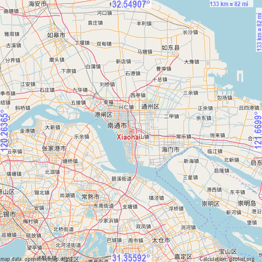
Xiaohai GPS coordinates[2]
31° 57' 15.948" North, 120° 58' 0.372" East
| Map corner | latitude | longitude |
|---|---|---|
| Upper-left | 32.54907°, | 120.26365° |
| Center: | 31.95443°, | 120.96677° |
| Lower-right: | 31.35592°, | 121.6699° |
| Map W x H: | 132.7×132.7 km | = 82.5×82.5mi |
| max Lat: | 53.31946° ⇑39.1% North |
| Xiaohai: | 31.95443° |
| min Lat: | ⇓60.9% South 18.22056° |
| min Long | Xiaohai | max Long |
| 75.07348° | 120.96677° | 134.28917° |
| W 87.6%⇐ | ⇒12.4% E |
Elevation
Elevation of Xiaohai is 2 m = 7 ft, and this is 482.8 m = 1584 ft below average elevation for this country.
| Max E: |
5622 m = 18445 ft | 99.4% |
| Avg. | 484.8 m = 1591 ft | |
| Xiaohai | 2 m = 7 ft | |
Min E: |
-3 m = -10 ft | 0.6% |
See also: China elevation on elevation.city.
Geographical zone
Xiaohai is located in North temperate zone (between Tropic of Cancer and the Arctic Circle). Distance of this Northern Tropic circle is 947.1 km =588.5 mi to South.| Distance of | km | miles | from Xiaohai |
|---|---|---|---|
| North Pole | 6454.1 | 4010.4 | to North |
| Arctic Circle | 3848.2 | 2391.2 | to North |
| Tropic Cancer | 947.1 | 588.5 | to South |
| Equator | 3553 | 2207.7 | to South |


Nearby cities:
15 places around Xiaohai: (largest is in red/bold)
• Chuangang
9.6 km =6 mi,  107°
107°
• Guanyinshan
6.8 km =4.2 mi,  333°
333°
• Jiangzao
7.8 km =4.8 mi,  52°
52°
• Langshan
7.7 km =4.8 mi,  272°
272°
• Nantong
12.1 km =7.5 mi,  314°
314°
• Rengang
13.9 km =8.6 mi,  296°
296°
• Sanxing
14.1 km =8.8 mi,  83°
83°
• Tianbu
14.2 km =8.8 mi,  102°
102°
• Xianfeng
6.3 km =3.9 mi,  10°
10°
• Xingdong
14.3 km =8.9 mi,  0°
0°
• Xingren
12.5 km =7.8 mi,  348°
348°
• Xinkai
5.4 km =3.4 mi,  213°
213°
• Yongxing
5.6 km =3.5 mi,  231°
231°
• Zhangzhishan
4.8 km =3 mi,  129°
129°
• Zhuhang
6.2 km =3.9 mi,  166°
166°
Sources, notices
• [Note1] Compared only with cities in China existing in our database
• [Src1] Map data: © OpenStreetMap contributors (CC-BY-SA)
• [Src2] Other city data from geonames.org with taken over terms of usage.
• [Src3] Geographical zone / Annual Mean Temperature by Robert A. Rohde @ Wikipedia
