Yongfeng geodata
Yongfeng (Shaanxi) is a seat of a fourth-order administrative division; located in China in Asia/Shanghai (GMT+8) time zone. In our database, there are 1268 cities with bigger population. Compared to other cities in China, 75% of cities are located further ↓South; 71.9% of cities are located further →East and 70.7% of cities have lower elevation than Yongfeng. Note1


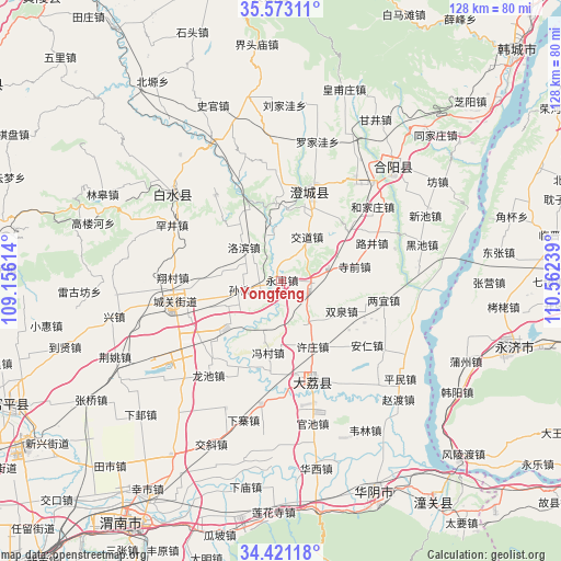
Yongfeng GPS coordinates[2]
34° 59' 57.012" North, 109° 51' 33.336" East
| Map corner | latitude | longitude |
|---|---|---|
| Upper-left | 35.57311°, | 109.15614° |
| Center: | 34.99917°, | 109.85926° |
| Lower-right: | 34.42118°, | 110.56239° |
| Map W x H: | 128.1×128.1 km | = 79.6×79.6mi |
| max Lat: | 53.31946° ⇑25% North |
| Yongfeng: | 34.99917° |
| min Lat: | ⇓75% South 18.22056° |
| min Long | Yongfeng | max Long |
| 75.07348° | 109.85926° | 134.28917° |
| W 28.1%⇐ | ⇒71.9% E |
Elevation
Elevation of Yongfeng is 425 m = 1394 ft, and this is 59.8 m = 196 ft below average elevation for this country.
| Max E: |
5622 m = 18445 ft | 29.3% |
| Avg. | 484.8 m = 1591 ft | |
| Yongfeng | 425 m = 1394 ft | |
Min E: |
-3 m = -10 ft | 70.7% |
See also: China elevation on elevation.city.
Geographical zone
Yongfeng is located in North temperate zone (between Tropic of Cancer and the Arctic Circle). Distance of this Northern Tropic circle is 1285.6 km =798.8 mi to South.| Distance of | km | miles | from Yongfeng |
|---|---|---|---|
| North Pole | 6115.5 | 3800 | to North |
| Arctic Circle | 3509.6 | 2180.8 | to North |
| Tropic Cancer | 1285.6 | 798.8 | to South |
| Equator | 3891.5 | 2418.1 | to South |


Nearby cities:
15 places around Yongfeng: (largest is in red/bold)
• Chunlin
17.1 km =10.6 mi,  255°
255°
• Dali
23.7 km =14.7 mi,  162°
162°
• Dongchen
4.8 km =3 mi,  272°
272°
• Dongyang
22.4 km =13.9 mi,  249°
249°
• Duanjia
14.6 km =9.1 mi,  194°
194°
• Fengcun
16.6 km =10.3 mi, 190°
• Longchi
27.1 km =16.8 mi,  217°
217°
• Longyang
23.2 km =14.4 mi, 222°
• Nianqiao
21.2 km =13.2 mi,  179°
179°
• Pinglumiao
15.1 km =9.4 mi,  228°
228°
• Pucheng Chengguanzhen
25.5 km =15.8 mi, 259°
• Sunzhen
9.8 km =6.1 mi, 259°
• Weizhuang
6.8 km =4.2 mi,  114°
114°
• Xiangcunxiang
24.9 km =15.5 mi, 272°
• Xuzhuang
16.7 km =10.4 mi,  153°
153°
Sources, notices
• [Note1] Compared only with cities in China existing in our database
• [Src1] Map data: © OpenStreetMap contributors (CC-BY-SA)
• [Src2] Other city data from geonames.org with taken over terms of usage.
• [Src3] Geographical zone / Annual Mean Temperature by Robert A. Rohde @ Wikipedia
