Yijing geodata
Yijing (Shaanxi) is a seat of a fourth-order administrative division; located in China in Asia/Shanghai (GMT+8) time zone. In our database, there are 1268 cities with bigger population. Compared to other cities in China, 73.1% of cities are located further ↓South; 80.2% of cities are located further →East and 83.2% of cities have lower elevation than Yijing. Note1


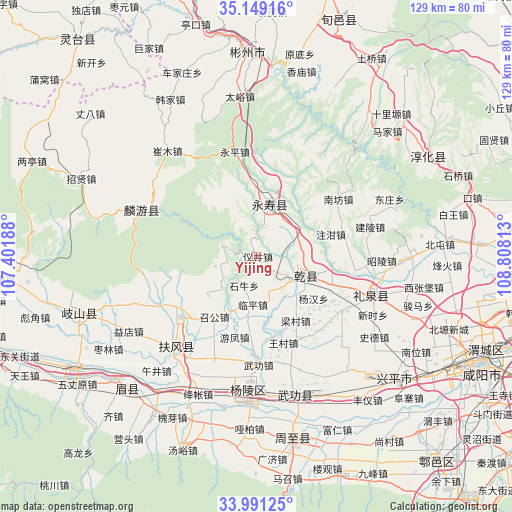
Yijing GPS coordinates[2]
34° 34' 19.992" North, 108° 6' 18" East
| Map corner | latitude | longitude |
|---|---|---|
| Upper-left | 35.14916°, | 107.40188° |
| Center: | 34.57222°, | 108.105° |
| Lower-right: | 33.99125°, | 108.80813° |
| Map W x H: | 128.7×128.7 km | = 80×80mi |
| max Lat: | 53.31946° ⇑26.9% North |
| Yijing: | 34.57222° |
| min Lat: | ⇓73.1% South 18.22056° |
| min Long | Yijing | max Long |
| 75.07348° | 108.105° | 134.28917° |
| W 19.8%⇐ | ⇒80.2% E |
Elevation
Elevation of Yijing is 862 m = 2828 ft, and this is 377.2 m = 1238 ft above average elevation for this country.
| Max E: |
5622 m = 18445 ft | 16.8% |
| Yijing | 862 m 2828 ft | |
| Avg. | 484.8 m = 1591 ft | |
Min E: |
-3 m = -10 ft | 83.2% |
See also: China elevation on elevation.city.
Geographical zone
Yijing is located in North temperate zone (between Tropic of Cancer and the Arctic Circle). Distance of this Northern Tropic circle is 1238.2 km =769.4 mi to South.| Distance of | km | miles | from Yijing |
|---|---|---|---|
| North Pole | 6163 | 3829.5 | to North |
| Arctic Circle | 3557.1 | 2210.3 | to North |
| Tropic Cancer | 1238.2 | 769.4 | to South |
| Equator | 3844.1 | 2388.6 | to South |


Nearby cities:
15 places around Yijing: (largest is in red/bold)
• Ganjing
16.9 km =10.5 mi,  347°
347°
• Guantou
9.9 km =6.2 mi,  343°
343°
• Jianjun
13.6 km =8.5 mi,  13°
13°
• Liangshan
9.7 km =6 mi,  56°
56°
• Linping
12 km =7.5 mi,  183°
183°
• Moxi
10 km =6.2 mi,  129°
129°
• Nanyang
18.6 km =11.6 mi,  239°
239°
• Shiniu
7.8 km =4.8 mi,  202°
202°
• Tiandu
15.8 km =9.8 mi, 235°
• Xinyang
10.4 km =6.5 mi,  161°
161°
• Yangyu
12.3 km =7.6 mi,  51°
51°
• Yujiagong
19 km =11.8 mi,  23°
23°
• Zhaogong
18.3 km =11.4 mi,  215°
215°
• Zhoucheng
15.2 km =9.4 mi,  174°
174°
• Zhuganzhen
19.5 km =12.1 mi,  72°
72°
Sources, notices
• [Note1] Compared only with cities in China existing in our database
• [Src1] Map data: © OpenStreetMap contributors (CC-BY-SA)
• [Src2] Other city data from geonames.org with taken over terms of usage.
• [Src3] Geographical zone / Annual Mean Temperature by Robert A. Rohde @ Wikipedia
