Tiandu geodata
Tiandu (Shaanxi) is a seat of a fourth-order administrative division; located in China in Asia/Shanghai (GMT+8) time zone. In our database, there are 1268 cities with bigger population. Compared to other cities in China, 72.7% of cities are located further ↓South; 80.7% of cities are located further →East and 79.5% of cities have lower elevation than Tiandu. Note1


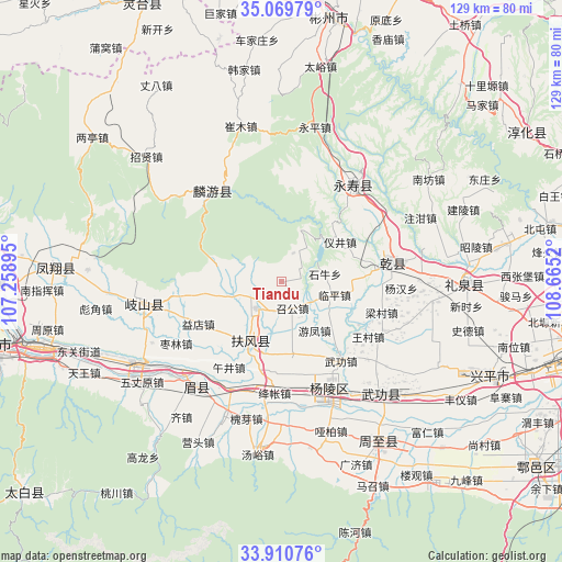
Tiandu GPS coordinates[2]
34° 29' 32.244" North, 107° 57' 43.452" East
| Map corner | latitude | longitude |
|---|---|---|
| Upper-left | 35.06979°, | 107.25895° |
| Center: | 34.49229°, | 107.96207° |
| Lower-right: | 33.91076°, | 108.6652° |
| Map W x H: | 128.9×128.9 km | = 80.1×80.1mi |
| max Lat: | 53.31946° ⇑27.3% North |
| Tiandu: | 34.49229° |
| min Lat: | ⇓72.7% South 18.22056° |
| min Long | Tiandu | max Long |
| 75.07348° | 107.96207° | 134.28917° |
| W 19.3%⇐ | ⇒80.7% E |
Elevation
Elevation of Tiandu is 671 m = 2201 ft, and this is 186.2 m = 611 ft above average elevation for this country.
| Max E: |
5622 m = 18445 ft | 20.5% |
| Tiandu | 671 m 2201 ft | |
| Avg. | 484.8 m = 1591 ft | |
Min E: |
-3 m = -10 ft | 79.5% |
See also: China elevation on elevation.city.
Geographical zone
Tiandu is located in North temperate zone (between Tropic of Cancer and the Arctic Circle). Distance of this Northern Tropic circle is 1229.3 km =763.9 mi to South.| Distance of | km | miles | from Tiandu |
|---|---|---|---|
| North Pole | 6171.9 | 3835 | to North |
| Arctic Circle | 3566 | 2215.8 | to North |
| Tropic Cancer | 1229.3 | 763.9 | to South |
| Equator | 3835.2 | 2383.1 | to South |


Nearby cities:
15 places around Tiandu: (largest is in red/bold)
• Famen
8.5 km =5.3 mi,  223°
223°
• Fufeng
16.8 km =10.4 mi,  209°
209°
• Jingdang
12.7 km =7.9 mi,  269°
269°
• Linping
12.7 km =7.9 mi,  104°
104°
• Nanyang
3 km =1.9 mi,  259°
259°
• Qinghua
13.7 km =8.5 mi,  237°
237°
• Shiniu
10.3 km =6.4 mi,  80°
80°
• Sufang
15.5 km =9.6 mi,  133°
133°
• Taibai
14.6 km =9.1 mi,  179°
179°
• Xinglin
16.7 km =10.4 mi,  171°
171°
• Xinyang
16.4 km =10.2 mi,  93°
93°
• Yijing
15.8 km =9.8 mi,  55°
55°
• Youfeng
13.5 km =8.4 mi,  146°
146°
• Zhaogong
6.5 km =4 mi,  157°
157°
• Zhoucheng
15.8 km =9.8 mi,  113°
113°
Sources, notices
• [Note1] Compared only with cities in China existing in our database
• [Src1] Map data: © OpenStreetMap contributors (CC-BY-SA)
• [Src2] Other city data from geonames.org with taken over terms of usage.
• [Src3] Geographical zone / Annual Mean Temperature by Robert A. Rohde @ Wikipedia
