Yanji geodata
Yanji (Hubei) is a seat of a fourth-order administrative division; located in China in Asia/Shanghai (GMT+8) time zone. In our database, there are 1268 cities with bigger population. Compared to other cities in China, 50.4% of cities are located further ↑North; 54.4% of cities are located further ←West and 89.9% of cities have higher elevation than Yanji. Note1


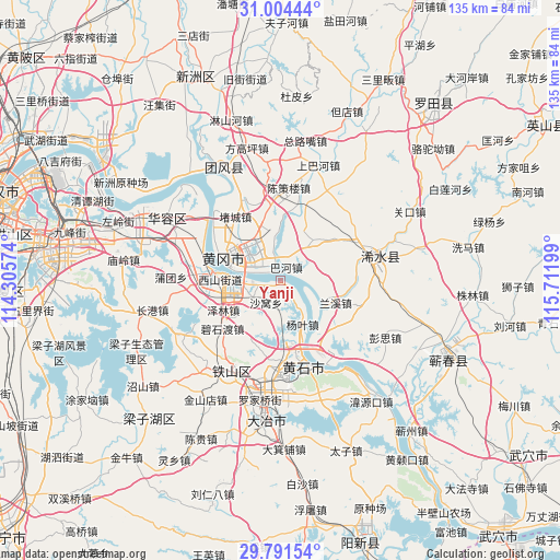
Yanji GPS coordinates[2]
30° 23' 59.532" North, 115° 0' 31.896" East
| Map corner | latitude | longitude |
|---|---|---|
| Upper-left | 31.00444°, | 114.30574° |
| Center: | 30.39987°, | 115.00886° |
| Lower-right: | 29.79154°, | 115.71199° |
| Map W x H: | 134.9×134.9 km | = 83.8×83.8mi |
| max Lat: | 53.31946° ⇑50.4% North |
| Yanji: | 30.39987° |
| min Lat: | ⇓49.6% South 18.22056° |
| min Long | Yanji | max Long |
| 75.07348° | 115.00886° | 134.28917° |
| W 54.4%⇐ | ⇒45.6% E |
Elevation
Elevation of Yanji is 10 m = 33 ft, and this is 474.8 m = 1558 ft below average elevation for this country.
| Max E: |
5622 m = 18445 ft | 89.9% |
| Avg. | 484.8 m = 1591 ft | |
| Yanji | 10 m = 33 ft | |
Min E: |
-3 m = -10 ft | 10.1% |
See also: China elevation on elevation.city.
Geographical zone
Yanji is located in North temperate zone (between Tropic of Cancer and the Arctic Circle). Distance of this Northern Tropic circle is 774.2 km =481.1 mi to South.| Distance of | km | miles | from Yanji |
|---|---|---|---|
| North Pole | 6626.9 | 4117.8 | to North |
| Arctic Circle | 4021 | 2498.5 | to North |
| Tropic Cancer | 774.2 | 481.1 | to South |
| Equator | 3380.1 | 2100.3 | to South |


Nearby cities:
15 places around Yanji: (largest is in red/bold)
• Bahe
3.5 km =2.2 mi,  22°
22°
• Dalukou
14 km =8.7 mi,  183°
183°
• Ducheng
19.4 km =12.1 mi,  326°
326°
• Ezhou
16.8 km =10.4 mi,  270°
270°
• E’zhou
11.7 km =7.3 mi, 267°
• Fankou
16.9 km =10.5 mi,  276°
276°
• Huanggang
14.5 km =9 mi,  293°
293°
• Huangshi
17.4 km =10.8 mi,  167°
167°
• Lanxi
14.1 km =8.8 mi,  114°
114°
• Liulin
19.6 km =12.2 mi,  137°
137°
• Lukou
12.4 km =7.7 mi, 326°
• Sanhua
20 km =12.4 mi,  151°
151°
• Taodian
16.1 km =10 mi,  344°
344°
• Xinmiao
8.1 km =5 mi,  260°
260°
• Yangye
10.9 km =6.8 mi, 149°
Sources, notices
• [Note1] Compared only with cities in China existing in our database
• [Src1] Map data: © OpenStreetMap contributors (CC-BY-SA)
• [Src2] Other city data from geonames.org with taken over terms of usage.
• [Src3] Geographical zone / Annual Mean Temperature by Robert A. Rohde @ Wikipedia
