Sanhua geodata
Sanhua (Hubei) is a seat of a fourth-order administrative division; located in China in Asia/Shanghai (GMT+8) time zone. In our database, there are 1268 cities with bigger population. Compared to other cities in China, 51.7% of cities are located further ↑North; 54.9% of cities are located further ←West and 79.8% of cities have higher elevation than Sanhua. Note1


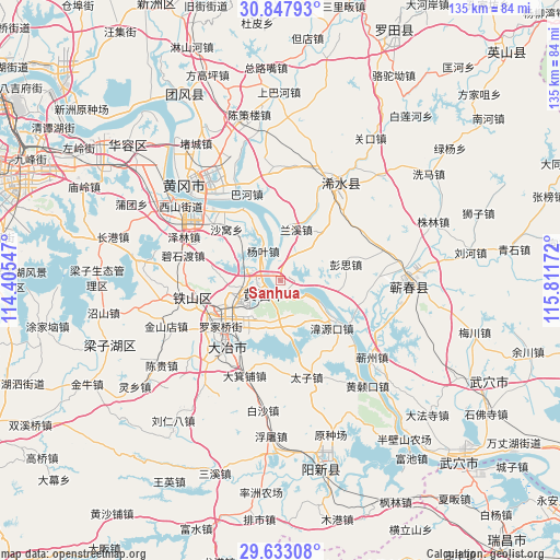
Sanhua GPS coordinates[2]
30° 14' 32.568" North, 115° 6' 30.924" East
| Map corner | latitude | longitude |
|---|---|---|
| Upper-left | 30.84793°, | 114.40547° |
| Center: | 30.24238°, | 115.10859° |
| Lower-right: | 29.63308°, | 115.81172° |
| Map W x H: | 135.1×135.1 km | = 83.9×83.9mi |
| max Lat: | 53.31946° ⇑51.7% North |
| Sanhua: | 30.24238° |
| min Lat: | ⇓48.3% South 18.22056° |
| min Long | Sanhua | max Long |
| 75.07348° | 115.10859° | 134.28917° |
| W 54.9%⇐ | ⇒45.1% E |
Elevation
Elevation of Sanhua is 27 m = 89 ft, and this is 457.8 m = 1502 ft below average elevation for this country.
| Max E: |
5622 m = 18445 ft | 79.8% |
| Avg. | 484.8 m = 1591 ft | |
| Sanhua | 27 m = 89 ft | |
Min E: |
-3 m = -10 ft | 20.2% |
See also: China elevation on elevation.city.
Geographical zone
Sanhua is located in North temperate zone (between Tropic of Cancer and the Arctic Circle). Distance of this Northern Tropic circle is 756.7 km =470.2 mi to South.| Distance of | km | miles | from Sanhua |
|---|---|---|---|
| North Pole | 6644.4 | 4128.6 | to North |
| Arctic Circle | 4038.5 | 2509.4 | to North |
| Tropic Cancer | 756.7 | 470.2 | to South |
| Equator | 3362.6 | 2089.4 | to South |


Nearby cities:
15 places around Sanhua: (largest is in red/bold)
• Dalukou
11.1 km =6.9 mi,  288°
288°
• Dengyue
8.4 km =5.2 mi,  222°
222°
• Guanyao
19.2 km =11.9 mi,  122°
122°
• Hekou
14.9 km =9.3 mi,  133°
133°
• Huangshi
5.8 km =3.6 mi,  275°
275°
• Lanxi
12.1 km =7.5 mi,  15°
15°
• Laoxialu
14.3 km =8.9 mi,  244°
244°
• Liulin
4.7 km =2.9 mi,  50°
50°
• Luoqiao
18.2 km =11.3 mi,  234°
234°
• Pengsi
16 km =9.9 mi,  77°
77°
• Tuanchengshan
8.9 km =5.5 mi, 239°
• Wangren
10 km =6.2 mi,  171°
171°
• Weiyuankou
17.1 km =10.6 mi,  135°
135°
• Xisaishan
6.8 km =4.2 mi, 121°
• Yangye
9 km =5.6 mi,  333°
333°
Sources, notices
• [Note1] Compared only with cities in China existing in our database
• [Src1] Map data: © OpenStreetMap contributors (CC-BY-SA)
• [Src2] Other city data from geonames.org with taken over terms of usage.
• [Src3] Geographical zone / Annual Mean Temperature by Robert A. Rohde @ Wikipedia
