Huangshi geodata
Huangshi (Hubei) is a seat of a second-order administrative division; located in China in Asia/Shanghai (GMT+8) time zone. With population of 688,090 people, there are 92 cities with bigger population in this country. Compared to other cities in China, 51.7% of cities are located further ↑North; 54.6% of cities are located further ←West and 82.1% of cities have higher elevation than Huangshi. Note1


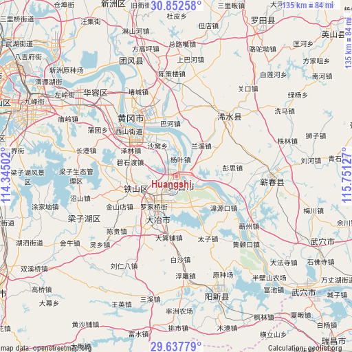
Huangshi GPS coordinates[2]
30° 14' 49.416" North, 115° 2' 53.304" East
| Map corner | latitude | longitude |
|---|---|---|
| Upper-left | 30.85258°, | 114.34502° |
| Center: | 30.24706°, | 115.04814° |
| Lower-right: | 29.63779°, | 115.75127° |
| Map W x H: | 135.1×135.1 km | = 83.9×83.9mi |
| max Lat: | 53.31946° ⇑51.7% North |
| Huangshi: | 30.24706° |
| min Lat: | ⇓48.3% South 18.22056° |
| min Long | Huangshi | max Long |
| 75.07348° | 115.04814° | 134.28917° |
| W 54.6%⇐ | ⇒45.4% E |
Elevation
Elevation of Huangshi is 22 m = 72 ft, and this is 462.8 m = 1518 ft below average elevation for this country.
| Max E: |
5622 m = 18445 ft | 82.1% |
| Avg. | 484.8 m = 1591 ft | |
| Huangshi | 22 m = 72 ft | |
Min E: |
-3 m = -10 ft | 17.9% |
See also: Huangshi elevation on elevation.city.
Geographical zone
Huangshi is located in North temperate zone (between Tropic of Cancer and the Arctic Circle). Distance of this Northern Tropic circle is 757.2 km =470.5 mi to South.| Distance of | km | miles | from Huangshi |
|---|---|---|---|
| North Pole | 6643.9 | 4128.3 | to North |
| Arctic Circle | 4038 | 2509.1 | to North |
| Tropic Cancer | 757.2 | 470.5 | to South |
| Equator | 3363.2 | 2089.8 | to South |


Nearby cities:
15 places around Huangshi: (largest is in red/bold)
• Dalukou
5.6 km =3.5 mi,  302°
302°
• Dengyue
6.8 km =4.2 mi,  178°
178°
• Dongfenglu
19 km =11.8 mi,  205°
205°
• Hekou
19.8 km =12.3 mi,  123°
123°
• Lanxi
14.3 km =8.9 mi,  39°
39°
• Laoxialu
9.7 km =6 mi,  226°
226°
• Liulin
9.7 km =6 mi,  75°
75°
• Luoqiao
14.3 km =8.9 mi,  218°
218°
• Sanhua
5.8 km =3.6 mi,  95°
95°
• Tuanchengshan
5.4 km =3.4 mi,  200°
200°
• Wangren
12.7 km =7.9 mi,  145°
145°
• Xinmiao
19.6 km =12.2 mi,  323°
323°
• Xisaishan
12.3 km =7.6 mi,  109°
109°
• Yangye
7.8 km =4.8 mi,  13°
13°
• Yanji
17.4 km =10.8 mi,  347°
347°
Sources, notices
• [Note1] Compared only with cities in China existing in our database
• [Src1] Map data: © OpenStreetMap contributors (CC-BY-SA)
• [Src2] Other city data from geonames.org with taken over terms of usage.
• [Src3] Geographical zone / Annual Mean Temperature by Robert A. Rohde @ Wikipedia
