Xixiang geodata
Xixiang (Shaanxi) is a seat of a third-order administrative division; located in China in Asia/Shanghai (GMT+8) time zone. In our database, there are 1268 cities with bigger population. Compared to other cities in China, 66% of cities are located further ↓South; 81.3% of cities are located further →East and 71.5% of cities have lower elevation than Xixiang. Note1


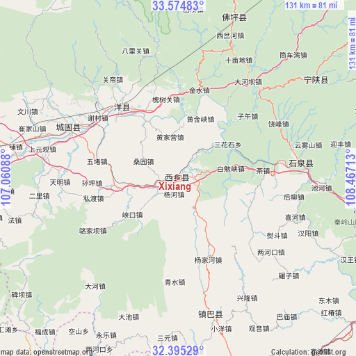
Xixiang GPS coordinates[2]
32° 59' 13.308" North, 107° 45' 50.4" East
| Map corner | latitude | longitude |
|---|---|---|
| Upper-left | 33.57483°, | 107.06088° |
| Center: | 32.98703°, | 107.764° |
| Lower-right: | 32.39529°, | 108.46713° |
| Map W x H: | 131.2×131.2 km | = 81.5×81.5mi |
| max Lat: | 53.31946° ⇑34% North |
| Xixiang: | 32.98703° |
| min Lat: | ⇓66% South 18.22056° |
| min Long | Xixiang | max Long |
| 75.07348° | 107.764° | 134.28917° |
| W 18.7%⇐ | ⇒81.3% E |
Elevation
Elevation of Xixiang is 440 m = 1444 ft, and this is 44.8 m = 147 ft below average elevation for this country.
| Max E: |
5622 m = 18445 ft | 28.5% |
| Avg. | 484.8 m = 1591 ft | |
| Xixiang | 440 m = 1444 ft | |
Min E: |
-3 m = -10 ft | 71.5% |
See also: China elevation on elevation.city.
Geographical zone
Xixiang is located in North temperate zone (between Tropic of Cancer and the Arctic Circle). Distance of this Northern Tropic circle is 1061.9 km =659.8 mi to South.| Distance of | km | miles | from Xixiang |
|---|---|---|---|
| North Pole | 6339.2 | 3939 | to North |
| Arctic Circle | 3733.4 | 2319.8 | to North |
| Tropic Cancer | 1061.9 | 659.8 | to South |
| Equator | 3667.8 | 2279.1 | to South |


Nearby cities:
15 places around Xixiang: (largest is in red/bold)
• Dahekan
68.1 km =42.3 mi,  275°
275°
• Gaojialing
68.4 km =42.5 mi,  265°
265°
• Hanyin Chengguanzhen
69.9 km =43.4 mi,  98°
98°
• Hanzhong
69.8 km =43.4 mi, 278°
• Hujiaying
69.1 km =42.9 mi, 273°
• Jingyang
53.5 km =33.2 mi,  167°
167°
• Laojun
68.8 km =42.8 mi, 282°
• Longjiang
76.5 km =47.5 mi, 281°
• Ningshan Chengguanzhen
63.4 km =39.4 mi,  52°
52°
• Qili
66.8 km =41.5 mi, 278°
• Wuxiang
70.2 km =43.6 mi,  288°
288°
• Xiangshui
64 km =39.8 mi, 265°
• Xinyuan
74.6 km =46.4 mi, 281°
• Yuanjiazhuang
63 km =39.1 mi,  18°
18°
• Zongying
75.4 km =46.9 mi, 284°
Sources, notices
• [Note1] Compared only with cities in China existing in our database
• [Src1] Map data: © OpenStreetMap contributors (CC-BY-SA)
• [Src2] Other city data from geonames.org with taken over terms of usage.
• [Src3] Geographical zone / Annual Mean Temperature by Robert A. Rohde @ Wikipedia
