Xitang geodata
Xitang (Zhejiang) is a seat of a fourth-order administrative division; located in China in Asia/Shanghai (GMT+8) time zone. In our database, there are 1268 cities with bigger population. Compared to other cities in China, 54.4% of cities are located further ↓South; 87.3% of cities are located further ←West and 92.7% of cities have higher elevation than Xitang. Note1


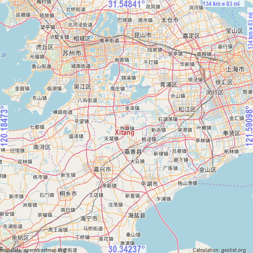
Xitang GPS coordinates[2]
30° 56' 50.244" North, 120° 53' 16.26" East
| Map corner | latitude | longitude |
|---|---|---|
| Upper-left | 31.54841°, | 120.18473° |
| Center: | 30.94729°, | 120.88785° |
| Lower-right: | 30.34237°, | 121.59098° |
| Map W x H: | 134.1×134.1 km | = 83.3×83.3mi |
| max Lat: | 53.31946° ⇑45.6% North |
| Xitang: | 30.94729° |
| min Lat: | ⇓54.4% South 18.22056° |
| min Long | Xitang | max Long |
| 75.07348° | 120.88785° | 134.28917° |
| W 87.3%⇐ | ⇒12.7% E |
Elevation
Elevation of Xitang is 8 m = 26 ft, and this is 476.8 m = 1564 ft below average elevation for this country.
| Max E: |
5622 m = 18445 ft | 92.7% |
| Avg. | 484.8 m = 1591 ft | |
| Xitang | 8 m = 26 ft | |
Min E: |
-3 m = -10 ft | 7.3% |
See also: China elevation on elevation.city.
Geographical zone
Xitang is located in North temperate zone (between Tropic of Cancer and the Arctic Circle). Distance of this Northern Tropic circle is 835.1 km =518.9 mi to South.| Distance of | km | miles | from Xitang |
|---|---|---|---|
| North Pole | 6566 | 4079.9 | to North |
| Arctic Circle | 3960.2 | 2460.8 | to North |
| Tropic Cancer | 835.1 | 518.9 | to South |
| Equator | 3441 | 2138.1 | to South |


Nearby cities:
15 places around Xitang: (largest is in red/bold)
• Dingzha
7.5 km =4.7 mi,  45°
45°
• Fengjing
13.4 km =8.3 mi,  118°
118°
• Fenhu
8.8 km =5.5 mi,  326°
326°
• Ganyao
6.5 km =4 mi,  182°
182°
• Hongxi
6.2 km =3.9 mi,  229°
229°
• Huimin
14.4 km =8.9 mi,  146°
146°
• Jiashan
11.5 km =7.1 mi,  161°
161°
• Jinze
10.3 km =6.4 mi,  14°
14°
• Qixing
16.5 km =10.3 mi,  205°
205°
• Taozhuang
8.1 km =5 mi,  287°
287°
• Tianning
10.1 km =6.3 mi,  235°
235°
• Weitang
11 km =6.8 mi,  168°
168°
• Xinbang
16.6 km =10.3 mi,  94°
94°
• Yangmiao
12.2 km =7.6 mi, 212°
• Yaozhuang
7.5 km =4.7 mi, 119°
Sources, notices
• [Note1] Compared only with cities in China existing in our database
• [Src1] Map data: © OpenStreetMap contributors (CC-BY-SA)
• [Src2] Other city data from geonames.org with taken over terms of usage.
• [Src3] Geographical zone / Annual Mean Temperature by Robert A. Rohde @ Wikipedia
