Ganyao geodata
Ganyao (Zhejiang) is a seat of a fourth-order administrative division; located in China in Asia/Shanghai (GMT+8) time zone. In our database, there are 1268 cities with bigger population. Compared to other cities in China, 53.7% of cities are located further ↓South; 87.3% of cities are located further ←West and 94.3% of cities have higher elevation than Ganyao. Note1


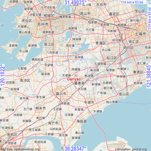
Ganyao GPS coordinates[2]
30° 53' 19.536" North, 120° 53' 7.152" East
| Map corner | latitude | longitude |
|---|---|---|
| Upper-left | 31.49025°, | 120.1822° |
| Center: | 30.88876°, | 120.88532° |
| Lower-right: | 30.28347°, | 121.58845° |
| Map W x H: | 134.2×134.2 km | = 83.4×83.4mi |
| max Lat: | 53.31946° ⇑46.3% North |
| Ganyao: | 30.88876° |
| min Lat: | ⇓53.7% South 18.22056° |
| min Long | Ganyao | max Long |
| 75.07348° | 120.88532° | 134.28917° |
| W 87.3%⇐ | ⇒12.7% E |
Elevation
Elevation of Ganyao is 7 m = 23 ft, and this is 477.8 m = 1568 ft below average elevation for this country.
| Max E: |
5622 m = 18445 ft | 94.3% |
| Avg. | 484.8 m = 1591 ft | |
| Ganyao | 7 m = 23 ft | |
Min E: |
-3 m = -10 ft | 5.7% |
See also: China elevation on elevation.city.
Geographical zone
Ganyao is located in North temperate zone (between Tropic of Cancer and the Arctic Circle). Distance of this Northern Tropic circle is 828.6 km =514.9 mi to South.| Distance of | km | miles | from Ganyao |
|---|---|---|---|
| North Pole | 6572.6 | 4084 | to North |
| Arctic Circle | 3966.7 | 2464.8 | to North |
| Tropic Cancer | 828.6 | 514.9 | to South |
| Equator | 3434.5 | 2134.1 | to South |


Nearby cities:
15 places around Ganyao: (largest is in red/bold)
• Dayun
13.1 km =8.1 mi,  153°
153°
• Dingzha
13 km =8.1 mi,  25°
25°
• Fengjing
12.1 km =7.5 mi,  89°
89°
• Fenhu
14.6 km =9.1 mi,  341°
341°
• Hongxi
5.1 km =3.2 mi,  298°
298°
• Huimin
9.8 km =6.1 mi,  124°
124°
• Jiashan
5.9 km =3.7 mi,  138°
138°
• Qixing
10.9 km =6.8 mi,  219°
219°
• Taozhuang
11.7 km =7.3 mi,  319°
319°
• Tianning
8.1 km =5 mi,  275°
275°
• Weitang
5 km =3.1 mi, 149°
• Xitang
6.5 km =4 mi,  2°
2°
• Yangmiao
7.3 km =4.5 mi,  239°
239°
• Yaozhuang
7.3 km =4.5 mi,  67°
67°
• Youchegang
14.7 km =9.1 mi, 243°
Sources, notices
• [Note1] Compared only with cities in China existing in our database
• [Src1] Map data: © OpenStreetMap contributors (CC-BY-SA)
• [Src2] Other city data from geonames.org with taken over terms of usage.
• [Src3] Geographical zone / Annual Mean Temperature by Robert A. Rohde @ Wikipedia
