Baicheng geodata
Baicheng (Henan) is a seat of a third-order administrative division; located in China in Asia/Shanghai (GMT+8) time zone. In our database, there are 1268 cities with bigger population. Compared to other cities in China, 67.7% of cities are located further ↓South; 51.3% of cities are located further →East and 66.6% of cities have higher elevation than Baicheng. Note1


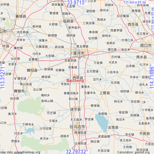
Baicheng GPS coordinates[2]
33° 23' 11.004" North, 114° 0' 56.988" East
| Map corner | latitude | longitude |
|---|---|---|
| Upper-left | 33.9715°, | 113.31271° |
| Center: | 33.38639°, | 114.01583° |
| Lower-right: | 32.79732°, | 114.71896° |
| Map W x H: | 130.6×130.6 km | = 81.2×81.2mi |
| max Lat: | 53.31946° ⇑32.3% North |
| Baicheng: | 33.38639° |
| min Lat: | ⇓67.7% South 18.22056° |
| min Long | Baicheng | max Long |
| 75.07348° | 114.01583° | 134.28917° |
| W 48.7%⇐ | ⇒51.3% E |
Elevation
Elevation of Baicheng is 66 m = 217 ft, and this is 418.8 m = 1374 ft below average elevation for this country.
| Max E: |
5622 m = 18445 ft | 66.6% |
| Avg. | 484.8 m = 1591 ft | |
| Baicheng | 66 m = 217 ft | |
Min E: |
-3 m = -10 ft | 33.4% |
See also: China elevation on elevation.city.
Geographical zone
Baicheng is located in North temperate zone (between Tropic of Cancer and the Arctic Circle). Distance of this Northern Tropic circle is 1106.3 km =687.4 mi to South.| Distance of | km | miles | from Baicheng |
|---|---|---|---|
| North Pole | 6294.8 | 3911.4 | to North |
| Arctic Circle | 3689 | 2292.2 | to North |
| Tropic Cancer | 1106.3 | 687.4 | to South |
| Equator | 3712.2 | 2306.7 | to South |


Nearby cities:
15 places around Baicheng: (largest is in red/bold)
• Chongyang
25.3 km =15.7 mi,  123°
123°
• Daliu
16.7 km =10.4 mi,  321°
321°
• Dizhuang
20.4 km =12.7 mi,  14°
14°
• Ganhechen
19.1 km =11.9 mi,  1°
1°
• Hexing
18.5 km =11.5 mi,  190°
190°
• Luohe
19.9 km =12.4 mi, 7°
• Quanzhai
15.9 km =9.9 mi,  293°
293°
• Shenzhai
21.7 km =13.5 mi,  219°
219°
• Shiling
18.3 km =11.4 mi,  273°
273°
• Songji
9.4 km =5.8 mi,  335°
335°
• Tandian
8.5 km =5.3 mi,  262°
262°
• Wucheng
25.3 km =15.7 mi, 286°
• Yancheng Chengguanzhen
22.2 km =13.8 mi,  353°
353°
• Yangzhuang
17.4 km =10.8 mi,  251°
251°
• Zhuantan
11.8 km =7.3 mi,  242°
242°
Sources, notices
• [Note1] Compared only with cities in China existing in our database
• [Src1] Map data: © OpenStreetMap contributors (CC-BY-SA)
• [Src2] Other city data from geonames.org with taken over terms of usage.
• [Src3] Geographical zone / Annual Mean Temperature by Robert A. Rohde @ Wikipedia
