Daliu geodata
Daliu (Henan) is a seat of a fourth-order administrative division; located in China in Asia/Shanghai (GMT+8) time zone. In our database, there are 1268 cities with bigger population. Compared to other cities in China, 68.1% of cities are located further ↓South; 52% of cities are located further →East and 65.8% of cities have higher elevation than Daliu. Note1


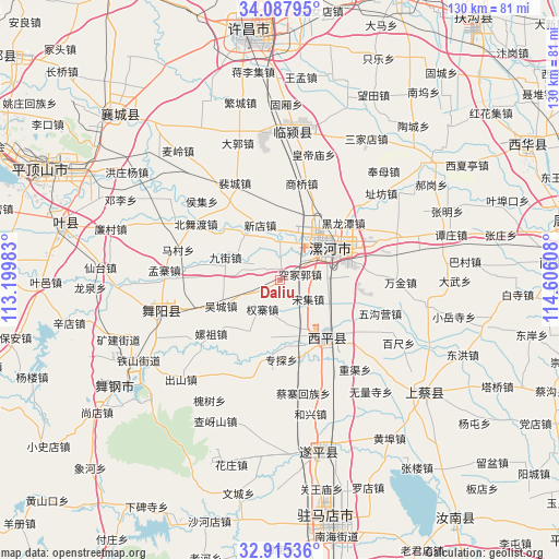
Daliu GPS coordinates[2]
33° 30' 13.104" North, 113° 54' 10.62" East
| Map corner | latitude | longitude |
|---|---|---|
| Upper-left | 34.08795°, | 113.19983° |
| Center: | 33.50364°, | 113.90295° |
| Lower-right: | 32.91536°, | 114.60608° |
| Map W x H: | 130.4×130.4 km | = 81×81mi |
| max Lat: | 53.31946° ⇑31.9% North |
| Daliu: | 33.50364° |
| min Lat: | ⇓68.1% South 18.22056° |
| min Long | Daliu | max Long |
| 75.07348° | 113.90295° | 134.28917° |
| W 48%⇐ | ⇒52% E |
Elevation
Elevation of Daliu is 69 m = 226 ft, and this is 415.8 m = 1364 ft below average elevation for this country.
| Max E: |
5622 m = 18445 ft | 65.8% |
| Avg. | 484.8 m = 1591 ft | |
| Daliu | 69 m = 226 ft | |
Min E: |
-3 m = -10 ft | 34.2% |
See also: China elevation on elevation.city.
Geographical zone
Daliu is located in North temperate zone (between Tropic of Cancer and the Arctic Circle). Distance of this Northern Tropic circle is 1119.3 km =695.5 mi to South.| Distance of | km | miles | from Daliu |
|---|---|---|---|
| North Pole | 6281.8 | 3903.3 | to North |
| Arctic Circle | 3675.9 | 2284.1 | to North |
| Tropic Cancer | 1119.3 | 695.5 | to South |
| Equator | 3725.3 | 2314.8 | to South |


Nearby cities:
15 places around Daliu: (largest is in red/bold)
• Baicheng
16.7 km =10.4 mi,  141°
141°
• Dizhuang
16.9 km =10.5 mi,  66°
66°
• Ganhechen
12.4 km =7.7 mi,  60°
60°
• Jiujie
13.9 km =8.6 mi,  292°
292°
• Lianhua
13 km =8.1 mi,  323°
323°
• Longcheng
11.6 km =7.2 mi,  5°
5°
• Luohe
14.6 km =9.1 mi, 62°
• Quanzhai
8 km =5 mi,  211°
211°
• Shiling
14.2 km =8.8 mi, 213°
• Songji
7.9 km =4.9 mi,  124°
124°
• Tandian
14.4 km =8.9 mi,  171°
171°
• Wucheng
15 km =9.3 mi,  246°
246°
• Xindian
13.7 km =8.5 mi,  339°
339°
• Yancheng Chengguanzhen
11.9 km =7.4 mi,  40°
40°
• Zhuantan
18.6 km =11.6 mi,  179°
179°
Sources, notices
• [Note1] Compared only with cities in China existing in our database
• [Src1] Map data: © OpenStreetMap contributors (CC-BY-SA)
• [Src2] Other city data from geonames.org with taken over terms of usage.
• [Src3] Geographical zone / Annual Mean Temperature by Robert A. Rohde @ Wikipedia
