Xiongkou geodata
Xiongkou (Hubei) is a seat of a fourth-order administrative division; located in China in Asia/Shanghai (GMT+8) time zone. In our database, there are 1268 cities with bigger population. Compared to other cities in China, 51.1% of cities are located further ↑North; 58.8% of cities are located further →East and 78.3% of cities have higher elevation than Xiongkou. Note1


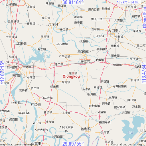
Xiongkou GPS coordinates[2]
30° 18' 23.256" North, 112° 46' 30.972" East
| Map corner | latitude | longitude |
|---|---|---|
| Upper-left | 30.91161°, | 112.07215° |
| Center: | 30.30646°, | 112.77527° |
| Lower-right: | 29.69755°, | 113.4784° |
| Map W x H: | 135×135 km | = 83.9×83.9mi |
| max Lat: | 53.31946° ⇑51.1% North |
| Xiongkou: | 30.30646° |
| min Lat: | ⇓48.9% South 18.22056° |
| min Long | Xiongkou | max Long |
| 75.07348° | 112.77527° | 134.28917° |
| W 41.2%⇐ | ⇒58.8% E |
Elevation
Elevation of Xiongkou is 30 m = 98 ft, and this is 454.8 m = 1492 ft below average elevation for this country.
| Max E: |
5622 m = 18445 ft | 78.3% |
| Avg. | 484.8 m = 1591 ft | |
| Xiongkou | 30 m = 98 ft | |
Min E: |
-3 m = -10 ft | 21.7% |
See also: China elevation on elevation.city.
Geographical zone
Xiongkou is located in North temperate zone (between Tropic of Cancer and the Arctic Circle). Distance of this Northern Tropic circle is 763.8 km =474.6 mi to South.| Distance of | km | miles | from Xiongkou |
|---|---|---|---|
| North Pole | 6637.3 | 4124.2 | to North |
| Arctic Circle | 4031.4 | 2505 | to North |
| Tropic Cancer | 763.8 | 474.6 | to South |
| Equator | 3369.8 | 2093.9 | to South |


Nearby cities:
15 places around Xiongkou: (largest is in red/bold)
• Guanghua
17.6 km =10.9 mi,  330°
330°
• Haokou
15.4 km =9.6 mi,  302°
302°
• Jiyukou
24.3 km =15.1 mi,  313°
313°
• Laoxin
14.8 km =9.2 mi,  150°
150°
• Maozui
27.6 km =17.1 mi,  63°
63°
• Qianjiang
17 km =10.6 mi,  41°
41°
• Wangchang
22.5 km =14 mi,  358°
358°
• Xingfu
26.5 km =16.5 mi,  119°
119°
• Xingou
25.9 km =16.1 mi,  138°
138°
• Yangshi
13.9 km =8.6 mi, 59°
• Yuyang
19.2 km =11.9 mi, 140°
• Zekou
22.1 km =13.7 mi,  24°
24°
• Zhangjin
20.9 km =13 mi,  234°
234°
• Zhouji
11.8 km =7.3 mi,  2°
2°
• Zhugentan
24.5 km =15.2 mi,  29°
29°
Sources, notices
• [Note1] Compared only with cities in China existing in our database
• [Src1] Map data: © OpenStreetMap contributors (CC-BY-SA)
• [Src2] Other city data from geonames.org with taken over terms of usage.
• [Src3] Geographical zone / Annual Mean Temperature by Robert A. Rohde @ Wikipedia
