Qianjiang geodata
Qianjiang (Hubei) is a seat of a fourth-order administrative division; located in China in Asia/Shanghai (GMT+8) time zone. With population of 179,079 people, there are 251 cities with bigger population in this country. Compared to other cities in China, 50.2% of cities are located further ↑North; 58.2% of cities are located further →East and 75.3% of cities have higher elevation than Qianjiang. Note1


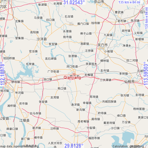
Qianjiang GPS coordinates[2]
30° 25' 15.6" North, 112° 53' 30.84" East
| Map corner | latitude | longitude |
|---|---|---|
| Upper-left | 31.02543°, | 112.18878° |
| Center: | 30.421°, | 112.8919° |
| Lower-right: | 29.8128°, | 113.59503° |
| Map W x H: | 134.8×134.8 km | = 83.8×83.8mi |
| max Lat: | 53.31946° ⇑50.2% North |
| Qianjiang: | 30.421° |
| min Lat: | ⇓49.8% South 18.22056° |
| min Long | Qianjiang | max Long |
| 75.07348° | 112.8919° | 134.28917° |
| W 41.8%⇐ | ⇒58.2% E |
Elevation
Elevation of Qianjiang is 36 m = 118 ft, and this is 448.8 m = 1472 ft below average elevation for this country.
| Max E: |
5622 m = 18445 ft | 75.3% |
| Avg. | 484.8 m = 1591 ft | |
| Qianjiang | 36 m = 118 ft | |
Min E: |
-3 m = -10 ft | 24.7% |
See also: Qianjiang elevation on elevation.city.
Geographical zone
Qianjiang is located in North temperate zone (between Tropic of Cancer and the Arctic Circle). Distance of this Northern Tropic circle is 776.6 km =482.6 mi to South.| Distance of | km | miles | from Qianjiang |
|---|---|---|---|
| North Pole | 6624.6 | 4116.3 | to North |
| Arctic Circle | 4018.7 | 2497.1 | to North |
| Tropic Cancer | 776.6 | 482.6 | to South |
| Equator | 3382.5 | 2101.8 | to South |


Nearby cities:
15 places around Qianjiang: (largest is in red/bold)
• Gaoshibei
25.8 km =16 mi,  304°
304°
• Guanghua
20 km =12.4 mi,  277°
277°
• Haokou
24.6 km =15.3 mi,  259°
259°
• Jiangchang
21.3 km =13.2 mi,  10°
10°
• Lijiazui
18.4 km =11.4 mi,  58°
58°
• Maozui
13.4 km =8.3 mi,  91°
91°
• Wangchang
15.4 km =9.6 mi,  309°
309°
• Wangchang
25.6 km =15.9 mi,  32°
32°
• Xiongkou
17 km =10.6 mi,  221°
221°
• Yangshi
5.7 km =3.5 mi,  172°
172°
• Zekou
7.6 km =4.7 mi,  345°
345°
• Zhanggang
16.9 km =10.5 mi,  355°
355°
• Zhengchang
15.3 km =9.5 mi, 58°
• Zhouji
10.7 km =6.6 mi, 264°
• Zhugentan
8.6 km =5.3 mi, 6°
Sources, notices
• [Note1] Compared only with cities in China existing in our database
• [Src1] Map data: © OpenStreetMap contributors (CC-BY-SA)
• [Src2] Other city data from geonames.org with taken over terms of usage.
• [Src3] Geographical zone / Annual Mean Temperature by Robert A. Rohde @ Wikipedia
