Xingou geodata
Xingou (Hubei) is a seat of a fourth-order administrative division; located in China in Asia/Shanghai (GMT+8) time zone. In our database, there are 1268 cities with bigger population. Compared to other cities in China, 52.7% of cities are located further ↑North; 57.8% of cities are located further →East and 76.2% of cities have higher elevation than Xingou. Note1


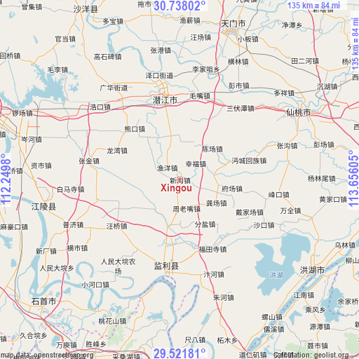
Xingou GPS coordinates[2]
30° 7' 54.444" North, 112° 57' 10.512" East
| Map corner | latitude | longitude |
|---|---|---|
| Upper-left | 30.73802°, | 112.2498° |
| Center: | 30.13179°, | 112.95292° |
| Lower-right: | 29.52181°, | 113.65605° |
| Map W x H: | 135.2×135.2 km | = 84×84mi |
| max Lat: | 53.31946° ⇑52.7% North |
| Xingou: | 30.13179° |
| min Lat: | ⇓47.3% South 18.22056° |
| min Long | Xingou | max Long |
| 75.07348° | 112.95292° | 134.28917° |
| W 42.2%⇐ | ⇒57.8% E |
Elevation
Elevation of Xingou is 34 m = 112 ft, and this is 450.8 m = 1479 ft below average elevation for this country.
| Max E: |
5622 m = 18445 ft | 76.2% |
| Avg. | 484.8 m = 1591 ft | |
| Xingou | 34 m = 112 ft | |
Min E: |
-3 m = -10 ft | 23.8% |
See also: China elevation on elevation.city.
Geographical zone
Xingou is located in North temperate zone (between Tropic of Cancer and the Arctic Circle). Distance of this Northern Tropic circle is 744.4 km =462.5 mi to South.| Distance of | km | miles | from Xingou |
|---|---|---|---|
| North Pole | 6656.7 | 4136.3 | to North |
| Arctic Circle | 4050.8 | 2517 | to North |
| Tropic Cancer | 744.4 | 462.5 | to South |
| Equator | 3350.3 | 2081.8 | to South |


Nearby cities:
15 places around Xingou: (largest is in red/bold)
• Caoshi
25.6 km =15.9 mi,  99°
99°
• Chenchang
16.9 km =10.5 mi,  44°
44°
• Fenyan
19 km =11.8 mi,  150°
150°
• Fuchang
19.6 km =12.2 mi, 100°
• Gongchang
16.2 km =10.1 mi,  121°
121°
• Huangxiekou
14.6 km =9.1 mi,  221°
221°
• Laoxin
11.7 km =7.3 mi,  303°
303°
• Maoshi
26.5 km =16.5 mi,  168°
168°
• Tonghaikou
20.3 km =12.6 mi,  69°
69°
• Wangshi
14.8 km =9.2 mi, 98°
• Xingfu
8.6 km =5.3 mi, 43°
• Xiongkou
25.9 km =16.1 mi,  318°
318°
• Yangshi
26.9 km =16.7 mi,  349°
349°
• Yuyang
6.7 km =4.2 mi,  314°
314°
• Zhoulaozui
11.2 km =7 mi, 166°
Sources, notices
• [Note1] Compared only with cities in China existing in our database
• [Src1] Map data: © OpenStreetMap contributors (CC-BY-SA)
• [Src2] Other city data from geonames.org with taken over terms of usage.
• [Src3] Geographical zone / Annual Mean Temperature by Robert A. Rohde @ Wikipedia
