Xinzao geodata
Xinzao (Guangdong) is a seat of a fourth-order administrative division; located in China in Asia/Shanghai (GMT+8) time zone. In our database, there are 1268 cities with bigger population. Compared to other cities in China, 94.2% of cities are located further ↑North; 54.9% of cities are located further →East and 88.7% of cities have higher elevation than Xinzao. Note1


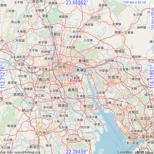
Xinzao GPS coordinates[2]
23° 2' 35.376" North, 113° 24' 57.168" East
| Map corner | latitude | longitude |
|---|---|---|
| Upper-left | 23.68862°, | 112.71276° |
| Center: | 23.04316°, | 113.41588° |
| Lower-right: | 22.39459°, | 114.11901° |
| Map W x H: | 143.9×143.9 km | = 89.4×89.4mi |
| max Lat: | 53.31946° ⇑94.2% North |
| Xinzao: | 23.04316° |
| min Lat: | ⇓5.8% South 18.22056° |
| min Long | Xinzao | max Long |
| 75.07348° | 113.41588° | 134.28917° |
| W 45.1%⇐ | ⇒54.9% E |
Elevation
Elevation of Xinzao is 11 m = 36 ft, and this is 473.8 m = 1554 ft below average elevation for this country.
| Max E: |
5622 m = 18445 ft | 88.7% |
| Avg. | 484.8 m = 1591 ft | |
| Xinzao | 11 m = 36 ft | |
Min E: |
-3 m = -10 ft | 11.3% |
See also: China elevation on elevation.city.
Geographical zone
Xinzao is located in North Torrid zone (between Equator and Tropic of Cancer). Distance of this Northern Tropic circle is 43.8 km =27.2 mi to North.| Distance of | km | miles | from Xinzao |
|---|---|---|---|
| North Pole | 7444.9 | 4626 | to North |
| Arctic Circle | 4839 | 3006.8 | to North |
| Tropic Cancer | 43.8 | 27.2 | to North |
| Equator | 2562.2 | 1592.1 | to South |


Nearby cities:
15 places around Xinzao: (largest is in red/bold)
• Changzhou
4.3 km =2.7 mi,  8°
8°
• Dalong
9.6 km =6 mi,  173°
173°
• Dasha
7.9 km =4.9 mi,  19°
19°
• Dashi
11.6 km =7.2 mi,  258°
258°
• Donghuan
12 km =7.5 mi,  204°
204°
• Hongshan
8.3 km =5.2 mi,  37°
37°
• Hualong
3.4 km =2.1 mi,  86°
86°
• Huangcun
9.6 km =6 mi,  355°
355°
• Nancun
4.2 km =2.6 mi,  220°
220°
• Shilou
10.6 km =6.6 mi,  136°
136°
• Shiqi
9.8 km =6.1 mi, 169°
• Shiqiao
12.3 km =7.6 mi,  208°
208°
• Suidong
10.3 km =6.4 mi,  63°
63°
• Xiaoguwei
5.5 km =3.4 mi,  265°
265°
• Yuzhu
6.7 km =4.2 mi, 10°
Sources, notices
• [Note1] Compared only with cities in China existing in our database
• [Src1] Map data: © OpenStreetMap contributors (CC-BY-SA)
• [Src2] Other city data from geonames.org with taken over terms of usage.
• [Src3] Geographical zone / Annual Mean Temperature by Robert A. Rohde @ Wikipedia
