Dasha geodata
Dasha (Guangdong) is a seat of a fourth-order administrative division; located in China in Asia/Shanghai (GMT+8) time zone. With population of 116,307 people, there are 373 cities with bigger population in this country. Compared to other cities in China, 93.9% of cities are located further ↑North; 54.7% of cities are located further →East and 86.9% of cities have higher elevation than Dasha. Note1


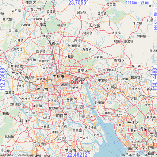
Dasha GPS coordinates[2]
23° 6' 37.332" North, 113° 26' 30.48" East
| Map corner | latitude | longitude |
|---|---|---|
| Upper-left | 23.7555°, | 112.73868° |
| Center: | 23.11037°, | 113.4418° |
| Lower-right: | 22.46212°, | 114.14493° |
| Map W x H: | 143.8×143.8 km | = 89.4×89.4mi |
| max Lat: | 53.31946° ⇑93.9% North |
| Dasha: | 23.11037° |
| min Lat: | ⇓6.1% South 18.22056° |
| min Long | Dasha | max Long |
| 75.07348° | 113.4418° | 134.28917° |
| W 45.3%⇐ | ⇒54.7% E |
Elevation
Elevation of Dasha is 13 m = 43 ft, and this is 471.8 m = 1548 ft below average elevation for this country.
| Max E: |
5622 m = 18445 ft | 86.9% |
| Avg. | 484.8 m = 1591 ft | |
| Dasha | 13 m = 43 ft | |
Min E: |
-3 m = -10 ft | 13.1% |
See also: Dasha elevation on elevation.city.
Geographical zone
Dasha is located in North Torrid zone (between Equator and Tropic of Cancer). Distance of this Northern Tropic circle is 36.3 km =22.6 mi to North.| Distance of | km | miles | from Dasha |
|---|---|---|---|
| North Pole | 7437.4 | 4621.4 | to North |
| Arctic Circle | 4831.5 | 3002.2 | to North |
| Tropic Cancer | 36.3 | 22.6 | to North |
| Equator | 2569.6 | 1596.7 | to South |


Nearby cities:
15 places around Dasha: (largest is in red/bold)
• Changxing
12.3 km =7.6 mi,  307°
307°
• Changzhou
3.8 km =2.4 mi,  212°
212°
• Hongshan
2.6 km =1.6 mi,  109°
109°
• Hualong
7.3 km =4.5 mi,  174°
174°
• Huangcun
4.1 km =2.5 mi,  300°
300°
• Lilian
10.2 km =6.3 mi,  85°
85°
• Luogang
9.6 km =6 mi,  38°
38°
• Nancun
12 km =7.5 mi, 206°
• Nangang
10.3 km =6.4 mi,  95°
95°
• Suidong
7.2 km =4.5 mi, 113°
• Wushan
11.1 km =6.9 mi, 299°
• Xiaoguwei
11.3 km =7 mi,  225°
225°
• Xintang
6.8 km =4.2 mi,  328°
328°
• Xinzao
7.9 km =4.9 mi,  199°
199°
• Yuzhu
1.7 km =1.1 mi,  239°
239°
Sources, notices
• [Note1] Compared only with cities in China existing in our database
• [Src1] Map data: © OpenStreetMap contributors (CC-BY-SA)
• [Src2] Other city data from geonames.org with taken over terms of usage.
• [Src3] Geographical zone / Annual Mean Temperature by Robert A. Rohde @ Wikipedia
