Xinxu geodata
Xinxu (Guangdong) is a seat of a fourth-order administrative division; located in China in Asia/Shanghai (GMT+8) time zone. In our database, there are 1268 cities with bigger population. Compared to other cities in China, 90.2% of cities are located further ↑North; 59.3% of cities are located further ←West and 57.9% of cities have higher elevation than Xinxu. Note1


Xinxu GPS coordinates[2]
24° 3' 21.42" North, 115° 51' 53.532" East
| Map corner | latitude | longitude |
|---|---|---|
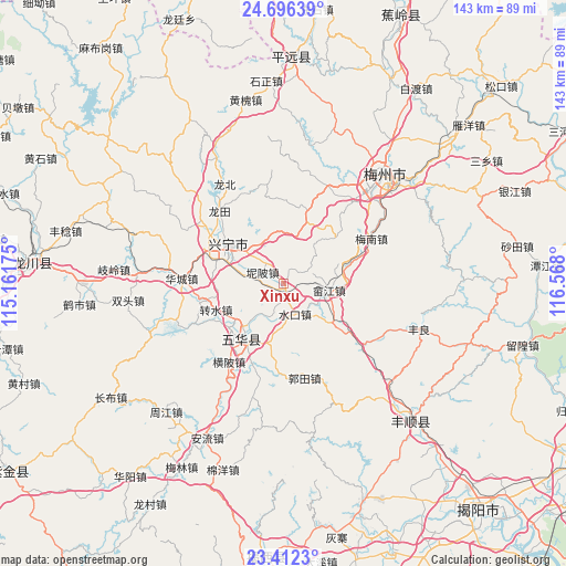
| Upper-left | 24.69639°, | 115.16175° |
| Center: | 24.05595°, | 115.86487° |
| Lower-right: | 23.4123°, | 116.568° |
| Map W x H: | 142.8×142.8 km | = 88.7×88.7mi |
| max Lat: | 53.31946° ⇑90.2% North |
| Xinxu: | 24.05595° |
| min Lat: | ⇓9.8% South 18.22056° |
| min Long | Xinxu | max Long |
| 75.07348° | 115.86487° | 134.28917° |
| W 59.3%⇐ | ⇒40.7% E |
Elevation
Elevation of Xinxu is 112 m = 367 ft, and this is 372.8 m = 1223 ft below average elevation for this country.
| Max E: |
5622 m = 18445 ft | 57.9% |
| Avg. | 484.8 m = 1591 ft | |
| Xinxu | 112 m = 367 ft | |
Min E: |
-3 m = -10 ft | 42.1% |
See also: China elevation on elevation.city.
Geographical zone
Xinxu is located in North temperate zone (between Tropic of Cancer and the Arctic Circle). Distance of this Northern Tropic circle is 68.9 km =42.8 mi to South.| Distance of | km | miles | from Xinxu |
|---|---|---|---|
| North Pole | 7332.3 | 4556.1 | to North |
| Arctic Circle | 4726.4 | 2936.8 | to North |
| Tropic Cancer | 68.9 | 42.8 | to South |
| Equator | 2674.8 | 1662 | to South |


Nearby cities:
15 places around Xinxu: (largest is in red/bold)
• Diaofang
12.6 km =7.8 mi,  291°
291°
• Fuxing
16.7 km =10.4 mi,  298°
298°
• Hedong
17.4 km =10.8 mi,  209°
209°
• Hesi
17.1 km =10.6 mi,  48°
48°
• Jingnan
16.1 km =10 mi,  20°
20°
• Libei
10.3 km =6.4 mi,  313°
313°
• Nibei
5.8 km =3.6 mi, 298°
• Ningxin
14.4 km =8.9 mi, 309°
• Ningzhong
16.5 km =10.3 mi, 311°
• Shejiang
11.8 km =7.3 mi,  98°
98°
• Shuiche
16 km =9.9 mi,  76°
76°
• Shuikou
8.6 km =5.3 mi,  158°
158°
• Shuizhai
17.3 km =10.7 mi,  215°
215°
• Xingning
17.7 km =11 mi, 305°
• Yonghe
11.9 km =7.4 mi,  326°
326°
Sources, notices
• [Note1] Compared only with cities in China existing in our database
• [Src1] Map data: © OpenStreetMap contributors (CC-BY-SA)
• [Src2] Other city data from geonames.org with taken over terms of usage.
• [Src3] Geographical zone / Annual Mean Temperature by Robert A. Rohde @ Wikipedia
