Jingnan geodata
Jingnan (Guangdong) is a seat of a fourth-order administrative division; located in China in Asia/Shanghai (GMT+8) time zone. In our database, there are 1268 cities with bigger population. Compared to other cities in China, 89.6% of cities are located further ↑North; 59.6% of cities are located further ←West and 62.1% of cities have lower elevation than Jingnan. Note1


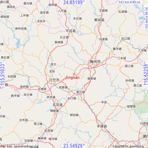
Jingnan GPS coordinates[2]
24° 11' 32.064" North, 115° 55' 10.02" East
| Map corner | latitude | longitude |
|---|---|---|
| Upper-left | 24.83199°, | 115.21633° |
| Center: | 24.19224°, | 115.91945° |
| Lower-right: | 23.54926°, | 116.62258° |
| Map W x H: | 142.6×142.6 km | = 88.6×88.6mi |
| max Lat: | 53.31946° ⇑89.6% North |
| Jingnan: | 24.19224° |
| min Lat: | ⇓10.4% South 18.22056° |
| min Long | Jingnan | max Long |
| 75.07348° | 115.91945° | 134.28917° |
| W 59.6%⇐ | ⇒40.4% E |
Elevation
Elevation of Jingnan is 284 m = 932 ft, and this is 200.8 m = 659 ft below average elevation for this country.
| Max E: |
5622 m = 18445 ft | 37.9% |
| Avg. | 484.8 m = 1591 ft | |
| Jingnan | 284 m = 932 ft | |
Min E: |
-3 m = -10 ft | 62.1% |
See also: China elevation on elevation.city.
Geographical zone
Jingnan is located in North temperate zone (between Tropic of Cancer and the Arctic Circle). Distance of this Northern Tropic circle is 84 km =52.2 mi to South.| Distance of | km | miles | from Jingnan |
|---|---|---|---|
| North Pole | 7317.1 | 4546.6 | to North |
| Arctic Circle | 4711.2 | 2927.4 | to North |
| Tropic Cancer | 84 | 52.2 | to South |
| Equator | 2689.9 | 1671.4 | to South |


Nearby cities:
15 places around Jingnan: (largest is in red/bold)
• Hesi
8.3 km =5.2 mi,  118°
118°
• Jingxin
4.3 km =2.7 mi,  19°
19°
• Libei
15.4 km =9.6 mi,  238°
238°
• Meinan
17.3 km =10.7 mi,  103°
103°
• Meixian
18.3 km =11.4 mi,  56°
56°
• Nankou
11.4 km =7.1 mi,  37°
37°
• Nibei
16.3 km =10.1 mi,  220°
220°
• Ningtang
17.5 km =10.9 mi,  263°
263°
• Ningxin
17.8 km =11.1 mi,  250°
250°
• Shejiang
17.9 km =11.1 mi,  160°
160°
• Shima
14.1 km =8.8 mi,  317°
317°
• Shuiche
15.3 km =9.5 mi,  138°
138°
• Xinxu
16.1 km =10 mi,  200°
200°
• Yaoshang
13.5 km =8.4 mi,  4°
4°
• Yonghe
13.2 km =8.2 mi, 246°
Sources, notices
• [Note1] Compared only with cities in China existing in our database
• [Src1] Map data: © OpenStreetMap contributors (CC-BY-SA)
• [Src2] Other city data from geonames.org with taken over terms of usage.
• [Src3] Geographical zone / Annual Mean Temperature by Robert A. Rohde @ Wikipedia
